


Garmin Singapore, Malaysia and Indonesia Charts BlueChart g3 | HXAE009R | microSD/SD
Garmin Singapore, Malaysia and Indonesia Charts BlueChart g3 | HXAE009R | microSD/SD
Model Number: 010-C0884-20
In stock
 WhatsApp
 SMS - Text us!
 Email Us!
 Help Desk

Tech Specs
In The Box
Do you have an old GPS unit lying around? The GPS Nation Trade In and Up program is a great way to trade in your old and used GPS for credit towards a new GPS. The choice is entirely yours! We’ve made the process simple and streamlined. Follow these simple steps, and you will be on your way to receiving credit towards your brand new GPS!
1. Get a quote
To get your free quote, provide your GPS type, manufacturer, model, and condition. Within 24 hours, you will receive a quote for the trade-in value of your current product. The GPS trade-in/trade-up form is at the bottom of this page.
2. Ship your product(s) for trade
After accepting our offer, pack your product(s) safely and ship them to us using the pre-paid shipping label provided to you. We will provide a confirmation email when your trade-in arrives at our warehouse. You have 30 days from the date you complete your on-line trade to ship the product to GPS Nation.
3. Make your purchase
Once we receive your product at our warehouse and we validate the stated condition, we will send you a confirmation email. If you elect to receive credit towards a new GPS at gpsnation.com, your store credit will be issued, and you are free to make your purchase.
Manual & Warranty
 Garmin Warranty
Reviews
Ask a Question
Tech Specs
In The Box
Trade-In
Do you have an old GPS unit lying around? The GPS Nation Trade In and Up program is a great way to trade in your old and used GPS for credit towards a new GPS. The choice is entirely yours! We’ve made the process simple and streamlined. Follow these simple steps, and you will be on your way to receiving credit towards your brand new GPS!
1. Get a quote
To get your free quote, provide your GPS type, manufacturer, model, and condition. Within 24 hours, you will receive a quote for the trade-in value of your current product. The GPS trade-in/trade-up form is at the bottom of this page.
2. Ship your product(s) for trade
After accepting our offer, pack your product(s) safely and ship them to us using the pre-paid shipping label provided to you. We will provide a confirmation email when your trade-in arrives at our warehouse. You have 30 days from the date you complete your on-line trade to ship the product to GPS Nation.
3. Make your purchase
Once we receive your product at our warehouse and we validate the stated condition, we will send you a confirmation email. If you elect to receive credit towards a new GPS at gpsnation.com, your store credit will be issued, and you are free to make your purchase.
Manual & Warranty
Overview
Garmin Singapore, Malaysia and Indonesia BlueChart g3 Navigation Charts microSD/SD Card
Introduction
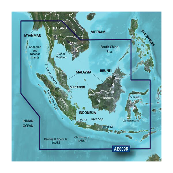
The Garmin BlueChart g3 Singapore, Malaysia, and Indonesia Charts (HXAE009R) delivers precise, continuously updated navigation data for Southeast Asian waters. This microSD/SD card combines official hydrographic surveys with private navigational sources to provide detailed chart coverage across one of the world's most complex maritime regions. Built for both professional mariners and recreational boaters, these charts enable confident navigation through shallow waters, busy shipping lanes, and intricate island passages across an area spanning from the Andaman Islands through Malaysia's coastlines to Indonesia's vast archipelago.
Key Features
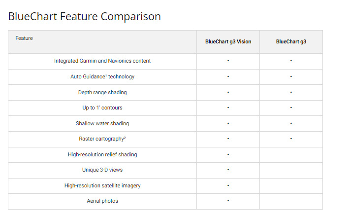
- Depth Range Shading with up to 10 customizable depth ranges for quick visual reference of underwater terrain
- 1-Foot Contour Intervals providing precision depth depictions critical for navigating shallow and complex waterways
- User-Defined Shallow Water Shading that highlights hazard zones at depths you specify for your vessel
- Comprehensive Coverage spanning southern Vietnam, Thailand, Cambodia, Malaysia, Brunei, and all major Indonesian islands including Borneo, Java, and Sulawesi
- Over 95% Chart Accuracy Rate ensuring reliable representation of seafloor features, navigation channels, and coastal hazards
- Regular Update Guarantee with discount card program to maintain current chart data reflecting channel changes, new hazards, and infrastructure updates
Data Insights
Achieving over 95% accuracy in chart representation, the BlueChart g3 series addresses a critical navigation challenge in Southeast Asia. These waters contain thousands of small islands, unpredictable depth changes, and seasonal variations that demand precise, frequently updated data. The inclusion of both official government survey data and independent merchant ship reports ensures you receive the most comprehensive and current intelligence available for the region.
Usage Instructions
Insert the microSD/SD card into your compatible Garmin chartplotter or marine GPS device. Update your charts regularly using the included discount card program through Garmin's update portal to access the latest navigational corrections and chart revisions. Familiarize yourself with the depth range shading and contour features before departing to maximize the chart's protective benefits during your passage.
Design & Material
The BlueChart g3 card format is engineered for maritime reliability without sacrificing portability. The microSD/SD card design allows secure storage in your device while remaining compact enough to transport across multiple vessels or backup systems.
- Weather-Resistant Card Construction maintaining data integrity and reliable performance across varying marine conditions
- Compact microSD/SD Format enabling secure insertion into standard Garmin chartplotters and compatible marine GPS units
- High-Resolution Chart Data delivering sharp, legible visualization of navigational channels and underwater features on larger displays
- Seamless Device Integration compatible with Garmin's full range of marine electronics including GPSMAP series plotters
- Durable Data Storage designed to withstand salt spray, moisture, and temperature fluctuations inherent to marine environments
- Robust Geographical Database containing detailed coverage of harbors, anchorages, navigation aids, and coastal infrastructure across the entire Southeast Asia region
Final Verdict
For boaters navigating the Singapore, Malaysia, and Indonesia region, the Garmin BlueChart g3 (HXAE009R) is not optional equipment—it is a foundational safety requirement. With 95% accuracy across one of the world's most challenging maritime areas, 1-foot depth contours for precision maneuvering, and continuous access to updated chart data, this card directly reduces grounding risk and navigational uncertainty. Whether you're conducting commercial operations, fishing expeditions, or island cruising, equip your vessel with this industry-standard chart system today and navigate with the confidence that comes from precise, current data.


