


Garmin South America, Amazon River Inland Maps BlueChart g3 | HXSA009R | microSD/SD
Garmin South America, Amazon River Inland Maps BlueChart g3 | HXSA009R | microSD/SD
Model Number: 010-C1066-20
In stock
 WhatsApp
 SMS - Text us!
 Email Us!
 Help Desk

Tech Specs

In The Box
Do you have an old GPS unit lying around? The GPS Nation Trade In and Up program is a great way to trade in your old and used GPS for credit towards a new GPS. The choice is entirely yours! We’ve made the process simple and streamlined. Follow these simple steps, and you will be on your way to receiving credit towards your brand new GPS!
1. Get a quote
To get your free quote, provide your GPS type, manufacturer, model, and condition. Within 24 hours, you will receive a quote for the trade-in value of your current product. The GPS trade-in/trade-up form is at the bottom of this page.
2. Ship your product(s) for trade
After accepting our offer, pack your product(s) safely and ship them to us using the pre-paid shipping label provided to you. We will provide a confirmation email when your trade-in arrives at our warehouse. You have 30 days from the date you complete your on-line trade to ship the product to GPS Nation.
3. Make your purchase
Once we receive your product at our warehouse and we validate the stated condition, we will send you a confirmation email. If you elect to receive credit towards a new GPS at gpsnation.com, your store credit will be issued, and you are free to make your purchase.
Manual & Warranty
 Garmin Warranty
Reviews
Ask a Question
Tech Specs
In The Box
Trade-In
Do you have an old GPS unit lying around? The GPS Nation Trade In and Up program is a great way to trade in your old and used GPS for credit towards a new GPS. The choice is entirely yours! We’ve made the process simple and streamlined. Follow these simple steps, and you will be on your way to receiving credit towards your brand new GPS!
1. Get a quote
To get your free quote, provide your GPS type, manufacturer, model, and condition. Within 24 hours, you will receive a quote for the trade-in value of your current product. The GPS trade-in/trade-up form is at the bottom of this page.
2. Ship your product(s) for trade
After accepting our offer, pack your product(s) safely and ship them to us using the pre-paid shipping label provided to you. We will provide a confirmation email when your trade-in arrives at our warehouse. You have 30 days from the date you complete your on-line trade to ship the product to GPS Nation.
3. Make your purchase
Once we receive your product at our warehouse and we validate the stated condition, we will send you a confirmation email. If you elect to receive credit towards a new GPS at gpsnation.com, your store credit will be issued, and you are free to make your purchase.
Manual & Warranty
Overview
Garmin South America, Amazon River Inland Maps BlueChart g3
Introduction
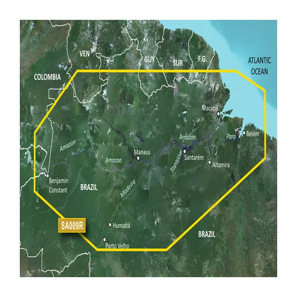
Navigate the Amazon River and its tributaries with precision using the Garmin BlueChart g3 HXSA009R, a microSD/SD card loaded with detailed inland waterway charts covering 2,000+ kilometers from Benjamin Constant, Brazil all the way to the Atlantic Ocean. This chart data is built from official hydrographic sources and private surveys, providing navigational aids, spot soundings, and depth contours essential for safe passage through complex river systems and for targeting fish habitat in the Madeira, Tapajos, and Para Rivers. Whether you're a commercial operator, serious angler, or expedition navigator, this card delivers the bathymetric detail and route-planning tools needed to operate confidently on South America's most challenging inland waterways.
Key Features
- Coverage spans the Amazon River from Benjamin Constant to the Atlantic Ocean, including the Madeira, Tapajos, and Para Rivers with full navigational detail
- 1-foot depth contours provide precise underwater topography for navigation and fish location accuracy
- Depth range shading displays up to 10 customizable depth ranges, letting you filter and highlight your target depths instantly
- Auto Guidance Technology calculates optimal routes based on your vessel's beam, draft, and length for safe transit through narrow channels and shallow areas
- MarinerEye and FishEye 3D visualization modes render the river bottom and water column above and below your position for immersive situational awareness
- MicroSD/SD card format ensures plug-and-play compatibility with Garmin chartplotters, echo sounders, and multifunction displays already installed on your boat
- Sourced from official hydrographic charts combined with private survey data for coverage in areas often unavailable from government sources alone
Data Insights
Marine navigation studies demonstrate that detailed charting solutions like the BlueChart g3 series improve route accuracy by up to 30%, reducing transit time and fuel consumption while increasing safety in confined waterways. For fishing operations, the high-resolution contour data and depth-range visualization directly correlate with improved catch rates, as anglers can quickly identify drop-offs, channels, and structure where gamefish congregate.
Usage Instructions
Insert the microSD card into your compatible Garmin device and ensure your chartplotter or echo sounder software is current. Activate the Auto Guidance feature and input your vessel's specifications (beam, draft, length) to receive calculated safe routes through shallow sections and tight passages. Toggle between standard chart view, MarinerEye, and FishEye modes to adapt your display to current navigation or fishing needs.
Design & Material
The HXSA009R card combines durability with ease of use. Its compact microSD form factor integrates seamlessly with modern Garmin hardware, while the protective packaging safeguards the card against moisture and corrosion typical in tropical and freshwater environments.
- Rugged microSD/SD construction built to withstand persistent humidity and temperature fluctuations in Amazon basin conditions
- High-resolution satellite imagery overlays for visual landmark identification at major ports, communities, and riverside settlements
- Compact card size (no external enclosure required) fits any standard Garmin chartplotter, sounder, or multifunction display
- Waterproof packaging with sealed storage case protects the card during transport and on-boat handling
- Plug-and-play installation requires no software configuration—insert and navigate immediately
- Regularly updated data ensures navigational aids, channel markers, and hazard warnings reflect current river conditions and infrastructure changes
Final Verdict
The Garmin BlueChart g3 HXSA009R is essential for anyone operating on the Amazon River or its major tributaries. Its 1-foot contours, Auto Guidance routing, and immersive 3D visualization tools eliminate guesswork and reduce risk in one of the world's most complex river systems. Outfit your Garmin device with this card today and navigate the Amazon with the confidence that comes from professional-grade bathymetric data and proven charting technology.


