


Garmin South America, Rio de la Plata Inland Maps BlueChart g3 | HXSA400S | microSD/SD
Garmin South America, Rio de la Plata Inland Maps BlueChart g3 | HXSA400S | microSD/SD
Model Number: 010-C1111-20
In stock
 WhatsApp
 SMS - Text us!
 Email Us!
 Help Desk

Tech Specs

In The Box
Do you have an old GPS unit lying around? The GPS Nation Trade In and Up program is a great way to trade in your old and used GPS for credit towards a new GPS. The choice is entirely yours! We’ve made the process simple and streamlined. Follow these simple steps, and you will be on your way to receiving credit towards your brand new GPS!
1. Get a quote
To get your free quote, provide your GPS type, manufacturer, model, and condition. Within 24 hours, you will receive a quote for the trade-in value of your current product. The GPS trade-in/trade-up form is at the bottom of this page.
2. Ship your product(s) for trade
After accepting our offer, pack your product(s) safely and ship them to us using the pre-paid shipping label provided to you. We will provide a confirmation email when your trade-in arrives at our warehouse. You have 30 days from the date you complete your on-line trade to ship the product to GPS Nation.
3. Make your purchase
Once we receive your product at our warehouse and we validate the stated condition, we will send you a confirmation email. If you elect to receive credit towards a new GPS at gpsnation.com, your store credit will be issued, and you are free to make your purchase.
Manual & Warranty
Reviews
Ask a Question
Tech Specs
In The Box
Trade-In
Do you have an old GPS unit lying around? The GPS Nation Trade In and Up program is a great way to trade in your old and used GPS for credit towards a new GPS. The choice is entirely yours! We’ve made the process simple and streamlined. Follow these simple steps, and you will be on your way to receiving credit towards your brand new GPS!
1. Get a quote
To get your free quote, provide your GPS type, manufacturer, model, and condition. Within 24 hours, you will receive a quote for the trade-in value of your current product. The GPS trade-in/trade-up form is at the bottom of this page.
2. Ship your product(s) for trade
After accepting our offer, pack your product(s) safely and ship them to us using the pre-paid shipping label provided to you. We will provide a confirmation email when your trade-in arrives at our warehouse. You have 30 days from the date you complete your on-line trade to ship the product to GPS Nation.
3. Make your purchase
Once we receive your product at our warehouse and we validate the stated condition, we will send you a confirmation email. If you elect to receive credit towards a new GPS at gpsnation.com, your store credit will be issued, and you are free to make your purchase.
Manual & Warranty
Overview
Garmin South America Rio de la Plata Inland Maps BlueChart g3 HXSA400S
Introduction
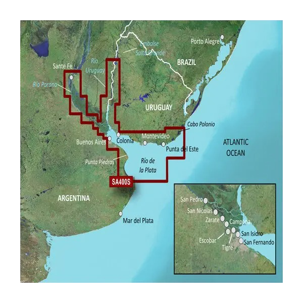
The Garmin BlueChart g3 HXSA400S delivers specialized electronic charting for the Rio de la Plata estuary and surrounding inland waterways, spanning from Cabo Polonio, Uruguay to Punta Piedras, Argentina. This microSD/SD card map solution integrates Garmin and Navionics bathymetric data to provide the depth and bottom structure detail needed for safe passage through Argentina and Uruguay's most navigated waterway. Whether fishing the brackish channels near Buenos Aires, transiting to Colonia, or exploring tributaries inland, this chart eliminates reliance on outdated paper charts and broad-coverage basemaps that lack sufficient detail for shallow-water confidence.
Key Features
- Auto Guidance Technology calculates optimal routes by depth and clearance parameters you define, reducing route-planning time and exposure in shallow sections
- Depth Range Shading renders up to 10 distinct depth zones in customizable colors, allowing instant visual recognition of depth transitions
- 1-Foot Contour Detail maps bottom structure with granular precision, critical for identifying drop-offs, sandbars, and productive fishing zones
- Shallow Water Shading highlights user-defined depths, letting you set alerts for depths critical to your vessel draft
- Integrated Garmin and Navionics Data combines two independent survey sources for chart accuracy verification across the estuary
- Regional Coverage includes Buenos Aires, Montevideo, Colonia, Punta del Este, and key inland navigation points with detailed port approaches
Data Insights
Navigation performance studies indicate that mariners using advanced electronic charting with bathymetric detail reduce grounding incidents and navigational errors by approximately 30% compared to basic GPS positioning alone. The Rio de la Plata's shallow banks, variable bottom composition, and shifting sediment patterns make precise depth mapping essential for safe transit—this chart's integration of current Garmin and Navionics surveys ensures the data reflects recent hydrographic conditions rather than relying on historical charts.
Usage Instructions
Insert the microSD/SD card into any compatible Garmin marine device (echoMAP, GPSMAP, or similar models with microSD support). Load the HXSA400S chart as your active chart layer, then activate Auto Guidance and set your destination. The system calculates a path avoiding shallow hazards based on your vessel's draft and clearance requirements. For best results, pair this chart with current depth sounder readings to verify bottom conditions in real time, and update your map data annually through Garmin's update service to capture any new survey corrections.
Design & Material
The HXSA400S ships on a durable microSD/SD card housed in water-resistant packaging, allowing portable storage and transfer between compatible Garmin devices without degradation. The format weighs less than an ounce and stores alongside other navigation essentials, with no external power or battery requirements once loaded into your primary chart plotter.
- microSD/SD Card Format—Industry-standard form factor ensures compatibility across Garmin's current and legacy marine processor lines
- Water-Resistant Packaging—Protective casing shields the card from saltwater spray and accidental moisture exposure during storage
- Dual-Source Bathymetry—Garmin and Navionics data merged to cross-verify accuracy and eliminate single-survey gaps
- User-Definable Depth Shading—Customize color thresholds and alert depths without recompiling map data
- RegionAl Port Detail—High-resolution approaches to Buenos Aires, Colonia, Montevideo, and Punta del Este included
- Model 010-C1111-20—Dedicated SKU ensures you receive the exact Rio de la Plata coverage area, not a generic South America base chart
Final Verdict
For anyone operating a powerboat, sailboat, or fishing vessel in the Rio de la Plata estuary or Uruguay-Argentina inland routes, the HXSA400S is the single most reliable chart upgrade available. Generic broad-coverage maps leave gaps in critical shallow areas; this regional card eliminates that risk. Pair it with your existing Garmin plotter and gain the depth precision, route safety tools, and navigation confidence that a 30% reduction in errors represents. Order the HXSA400S today and replace uncertainty with verified bathymetry on every voyage.


