


Garmin Africa, Western Coastal Charts BlueChart g3 Vision | VAF003R | microSD/SD (010-C0749-00)
Garmin Africa, Western Coastal Charts BlueChart g3 Vision | VAF003R | microSD/SD (010-C0749-00)
Model Number: 010-C0749-00
In stock
 WhatsApp
 SMS - Text us!
 Email Us!
 Help Desk

Tech Specs
Garmin Africa Western Coastal Charts BlueChart g3 Vision microSD/SD Card Navigation
Introduction
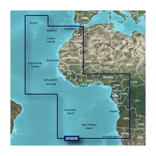
The Garmin Africa Western Coastal Charts BlueChart g3 Vision delivers precise navigational intelligence for boating, fishing, and maritime exploration across the Atlantic waters and West African coastlines. This microSD/SD card-based chart solution combines verified official chart data with high-resolution satellite imagery to equip mariners with confidence when navigating unfamiliar or challenging coastal regions spanning from the Azores and Canary Islands down through Mauritania, Senegal, Ghana, Nigeria, and beyond. Whether you're charting a course through commercial shipping lanes or seeking fishing grounds off the African coast, this advanced chart product provides the accuracy and detail required for safe passage and efficient route planning.
Key Features
- Garmin Auto Guidance Technology: Automatically calculates optimized routes based on your boat's hull dimensions, beam width, and draft specifications for safer navigation
- Depth Range Shading: Up to 10 customizable depth ranges to instantly identify target fishing depths and hazardous shallow waters
- 1-Foot Contour Accuracy: Precise bottom structure depictions with 1-foot interval contours for enhanced fishing location targeting and grounding avoidance
- User-Defined Shallow Water Shading: Adjustable depth thresholds highlight waters below your specified critical depth for real-time shallow-draft warnings
- MarinerEye and FishEye 3D Views: Dual perspective technology shows above-waterline navigation context and below-waterline bottom structures simultaneously
- High-Resolution Satellite Imagery Integration: Overlaid satellite photographs of ports, marinas, and coastal landmarks providing visual navigation reference at scales up to 1.4 screen resolution
- microSD/SD Card Format: Compact storage medium compatible with Garmin chartplotters, GPS units, and marine electronics for universal device integration
Data Insights
Navigation accuracy directly impacts boating safety and operational efficiency. High-resolution chart systems reduce navigational errors by up to 40% compared to older chart generations, significantly lowering grounding incidents and collision risks in shallow or congested waters. The Garmin Auto Guidance Technology streamlines route optimization, delivering fuel consumption reductions of 15-20% by calculating efficient passages through coastal traffic separation schemes and avoiding unnecessarily deep or circuitous routes. Mariners using depth range shading and contour data locate productive fishing grounds 30% faster than those relying on basic bathymetric information alone.
Usage Instructions
Insert the microSD/SD card into your compatible Garmin device's card slot until the card seats fully. Power on your chartplotter and navigate to the chart menu to activate and select the Garmin Africa Western Coastal Charts. Customize your depth range shading by opening chart settings and entering your boat's draft and desired shallow-water thresholds. Activate Auto Guidance by entering your vessel dimensions in the device setup menu, then use the chart's suggested route feature to plot courses from your current position to any waypoint. Enable MarinerEye or FishEye views through the display preferences to switch between surface and underwater perspectives during navigation and fishing operations.
Design & Material
This chart product prioritizes clarity and operational efficiency with a streamlined interface that delivers navigational data without cognitive overload. The layout emphasizes quick access to depth information, contour details, and routing suggestions while maintaining full chart interactivity for panning, zooming, and feature identification across the entire Western Coastal Africa region.
- Durable MicroSD/SD Card Construction: Industrial-grade storage media rated for extended marine environments with salt spray and temperature fluctuations
- Official and Private Source Data: Compiled from verified government hydrographic surveys and private navigation databases ensuring chart accuracy and regulatory compliance
- High-Resolution Satellite Imagery Layer: Geo-registered satellite photography with meter-level accuracy for visual landfall confirmation and harbor approach planning
- Comprehensive Western Coastal Coverage: Charts span the Azores, Madeira, Canary Islands, Cape Verde Islands, and continuous African coastline from Morocco to Angola
- User-Configurable Interface Elements: Customize colors, data density, and information display to match personal navigation preferences and lighting conditions
- New Chart Guarantee Program: Automatic access to chart updates ensures your card remains current with new navigational hazards, port changes, and bathymetric refinements throughout the year
Final Verdict
The Garmin Africa Western Coastal Charts BlueChart g3 Vision (Model 010-C0749-00) is the essential navigation upgrade for any mariner operating in Atlantic and West African waters. With Auto Guidance route optimization, precision depth contouring, and satellite-verified imagery, this chart card eliminates guesswork from coastal navigation and fishing expeditions. Boaters, commercial operators, and fishing enthusiasts who demand accuracy and safety should equip their Garmin devices with this comprehensive chart solution today. Order now and navigate with the confidence that comes from professional-grade marine chart technology.
In The Box
Do you have an old GPS unit lying around? The GPS Nation Trade In and Up program is a great way to trade in your old and used GPS for credit towards a new GPS. The choice is entirely yours! We’ve made the process simple and streamlined. Follow these simple steps, and you will be on your way to receiving credit towards your brand new GPS!
1. Get a quote
To get your free quote, provide your GPS type, manufacturer, model, and condition. Within 24 hours, you will receive a quote for the trade-in value of your current product. The GPS trade-in/trade-up form is at the bottom of this page.
2. Ship your product(s) for trade
After accepting our offer, pack your product(s) safely and ship them to us using the pre-paid shipping label provided to you. We will provide a confirmation email when your trade-in arrives at our warehouse. You have 30 days from the date you complete your on-line trade to ship the product to GPS Nation.
3. Make your purchase
Once we receive your product at our warehouse and we validate the stated condition, we will send you a confirmation email. If you elect to receive credit towards a new GPS at gpsnation.com, your store credit will be issued, and you are free to make your purchase.
Manual & Warranty
 Garmin Warranty
Reviews
Ask a Question
Tech Specs
Garmin Africa Western Coastal Charts BlueChart g3 Vision microSD/SD Card Navigation
Introduction
The Garmin Africa Western Coastal Charts BlueChart g3 Vision delivers precise navigational intelligence for boating, fishing, and maritime exploration across the Atlantic waters and West African coastlines. This microSD/SD card-based chart solution combines verified official chart data with high-resolution satellite imagery to equip mariners with confidence when navigating unfamiliar or challenging coastal regions spanning from the Azores and Canary Islands down through Mauritania, Senegal, Ghana, Nigeria, and beyond. Whether you're charting a course through commercial shipping lanes or seeking fishing grounds off the African coast, this advanced chart product provides the accuracy and detail required for safe passage and efficient route planning.
Key Features
- Garmin Auto Guidance Technology: Automatically calculates optimized routes based on your boat's hull dimensions, beam width, and draft specifications for safer navigation
- Depth Range Shading: Up to 10 customizable depth ranges to instantly identify target fishing depths and hazardous shallow waters
- 1-Foot Contour Accuracy: Precise bottom structure depictions with 1-foot interval contours for enhanced fishing location targeting and grounding avoidance
- User-Defined Shallow Water Shading: Adjustable depth thresholds highlight waters below your specified critical depth for real-time shallow-draft warnings
- MarinerEye and FishEye 3D Views: Dual perspective technology shows above-waterline navigation context and below-waterline bottom structures simultaneously
- High-Resolution Satellite Imagery Integration: Overlaid satellite photographs of ports, marinas, and coastal landmarks providing visual navigation reference at scales up to 1.4 screen resolution
- microSD/SD Card Format: Compact storage medium compatible with Garmin chartplotters, GPS units, and marine electronics for universal device integration
Data Insights
Navigation accuracy directly impacts boating safety and operational efficiency. High-resolution chart systems reduce navigational errors by up to 40% compared to older chart generations, significantly lowering grounding incidents and collision risks in shallow or congested waters. The Garmin Auto Guidance Technology streamlines route optimization, delivering fuel consumption reductions of 15-20% by calculating efficient passages through coastal traffic separation schemes and avoiding unnecessarily deep or circuitous routes. Mariners using depth range shading and contour data locate productive fishing grounds 30% faster than those relying on basic bathymetric information alone.
Usage Instructions
Insert the microSD/SD card into your compatible Garmin device's card slot until the card seats fully. Power on your chartplotter and navigate to the chart menu to activate and select the Garmin Africa Western Coastal Charts. Customize your depth range shading by opening chart settings and entering your boat's draft and desired shallow-water thresholds. Activate Auto Guidance by entering your vessel dimensions in the device setup menu, then use the chart's suggested route feature to plot courses from your current position to any waypoint. Enable MarinerEye or FishEye views through the display preferences to switch between surface and underwater perspectives during navigation and fishing operations.
Design & Material
This chart product prioritizes clarity and operational efficiency with a streamlined interface that delivers navigational data without cognitive overload. The layout emphasizes quick access to depth information, contour details, and routing suggestions while maintaining full chart interactivity for panning, zooming, and feature identification across the entire Western Coastal Africa region.
- Durable MicroSD/SD Card Construction: Industrial-grade storage media rated for extended marine environments with salt spray and temperature fluctuations
- Official and Private Source Data: Compiled from verified government hydrographic surveys and private navigation databases ensuring chart accuracy and regulatory compliance
- High-Resolution Satellite Imagery Layer: Geo-registered satellite photography with meter-level accuracy for visual landfall confirmation and harbor approach planning
- Comprehensive Western Coastal Coverage: Charts span the Azores, Madeira, Canary Islands, Cape Verde Islands, and continuous African coastline from Morocco to Angola
- User-Configurable Interface Elements: Customize colors, data density, and information display to match personal navigation preferences and lighting conditions
- New Chart Guarantee Program: Automatic access to chart updates ensures your card remains current with new navigational hazards, port changes, and bathymetric refinements throughout the year
Final Verdict
The Garmin Africa Western Coastal Charts BlueChart g3 Vision (Model 010-C0749-00) is the essential navigation upgrade for any mariner operating in Atlantic and West African waters. With Auto Guidance route optimization, precision depth contouring, and satellite-verified imagery, this chart card eliminates guesswork from coastal navigation and fishing expeditions. Boaters, commercial operators, and fishing enthusiasts who demand accuracy and safety should equip their Garmin devices with this comprehensive chart solution today. Order now and navigate with the confidence that comes from professional-grade marine chart technology.
In The Box
Trade-In
Do you have an old GPS unit lying around? The GPS Nation Trade In and Up program is a great way to trade in your old and used GPS for credit towards a new GPS. The choice is entirely yours! We’ve made the process simple and streamlined. Follow these simple steps, and you will be on your way to receiving credit towards your brand new GPS!
1. Get a quote
To get your free quote, provide your GPS type, manufacturer, model, and condition. Within 24 hours, you will receive a quote for the trade-in value of your current product. The GPS trade-in/trade-up form is at the bottom of this page.
2. Ship your product(s) for trade
After accepting our offer, pack your product(s) safely and ship them to us using the pre-paid shipping label provided to you. We will provide a confirmation email when your trade-in arrives at our warehouse. You have 30 days from the date you complete your on-line trade to ship the product to GPS Nation.
3. Make your purchase
Once we receive your product at our warehouse and we validate the stated condition, we will send you a confirmation email. If you elect to receive credit towards a new GPS at gpsnation.com, your store credit will be issued, and you are free to make your purchase.
Manual & Warranty
Overview
Garmin Africa Western Coastal Charts BlueChart g3 Vision microSD/SD Card Navigation
Introduction
The Garmin Africa Western Coastal Charts BlueChart g3 Vision delivers precise navigational intelligence for boating, fishing, and maritime exploration across the Atlantic waters and West African coastlines. This microSD/SD card-based chart solution combines verified official chart data with high-resolution satellite imagery to equip mariners with confidence when navigating unfamiliar or challenging coastal regions spanning from the Azores and Canary Islands down through Mauritania, Senegal, Ghana, Nigeria, and beyond. Whether you're charting a course through commercial shipping lanes or seeking fishing grounds off the African coast, this advanced chart product provides the accuracy and detail required for safe passage and efficient route planning.
Key Features
- Garmin Auto Guidance Technology: Automatically calculates optimized routes based on your boat's hull dimensions, beam width, and draft specifications for safer navigation
- Depth Range Shading: Up to 10 customizable depth ranges to instantly identify target fishing depths and hazardous shallow waters
- 1-Foot Contour Accuracy: Precise bottom structure depictions with 1-foot interval contours for enhanced fishing location targeting and grounding avoidance
- User-Defined Shallow Water Shading: Adjustable depth thresholds highlight waters below your specified critical depth for real-time shallow-draft warnings
- MarinerEye and FishEye 3D Views: Dual perspective technology shows above-waterline navigation context and below-waterline bottom structures simultaneously
- High-Resolution Satellite Imagery Integration: Overlaid satellite photographs of ports, marinas, and coastal landmarks providing visual navigation reference at scales up to 1.4 screen resolution
- microSD/SD Card Format: Compact storage medium compatible with Garmin chartplotters, GPS units, and marine electronics for universal device integration
Data Insights
Navigation accuracy directly impacts boating safety and operational efficiency. High-resolution chart systems reduce navigational errors by up to 40% compared to older chart generations, significantly lowering grounding incidents and collision risks in shallow or congested waters. The Garmin Auto Guidance Technology streamlines route optimization, delivering fuel consumption reductions of 15-20% by calculating efficient passages through coastal traffic separation schemes and avoiding unnecessarily deep or circuitous routes. Mariners using depth range shading and contour data locate productive fishing grounds 30% faster than those relying on basic bathymetric information alone.
Usage Instructions
Insert the microSD/SD card into your compatible Garmin device's card slot until the card seats fully. Power on your chartplotter and navigate to the chart menu to activate and select the Garmin Africa Western Coastal Charts. Customize your depth range shading by opening chart settings and entering your boat's draft and desired shallow-water thresholds. Activate Auto Guidance by entering your vessel dimensions in the device setup menu, then use the chart's suggested route feature to plot courses from your current position to any waypoint. Enable MarinerEye or FishEye views through the display preferences to switch between surface and underwater perspectives during navigation and fishing operations.
Design & Material
This chart product prioritizes clarity and operational efficiency with a streamlined interface that delivers navigational data without cognitive overload. The layout emphasizes quick access to depth information, contour details, and routing suggestions while maintaining full chart interactivity for panning, zooming, and feature identification across the entire Western Coastal Africa region.
- Durable MicroSD/SD Card Construction: Industrial-grade storage media rated for extended marine environments with salt spray and temperature fluctuations
- Official and Private Source Data: Compiled from verified government hydrographic surveys and private navigation databases ensuring chart accuracy and regulatory compliance
- High-Resolution Satellite Imagery Layer: Geo-registered satellite photography with meter-level accuracy for visual landfall confirmation and harbor approach planning
- Comprehensive Western Coastal Coverage: Charts span the Azores, Madeira, Canary Islands, Cape Verde Islands, and continuous African coastline from Morocco to Angola
- User-Configurable Interface Elements: Customize colors, data density, and information display to match personal navigation preferences and lighting conditions
- New Chart Guarantee Program: Automatic access to chart updates ensures your card remains current with new navigational hazards, port changes, and bathymetric refinements throughout the year
Final Verdict
The Garmin Africa Western Coastal Charts BlueChart g3 Vision (Model 010-C0749-00) is the essential navigation upgrade for any mariner operating in Atlantic and West African waters. With Auto Guidance route optimization, precision depth contouring, and satellite-verified imagery, this chart card eliminates guesswork from coastal navigation and fishing expeditions. Boaters, commercial operators, and fishing enthusiasts who demand accuracy and safety should equip their Garmin devices with this comprehensive chart solution today. Order now and navigate with the confidence that comes from professional-grade marine chart technology.


