


Garmin Africa, Eastern Coastal and Inland Charts BlueChart g3 Vision | VAF001R | microSD/SD (010-C0747-00)
Garmin Africa, Eastern Coastal and Inland Charts BlueChart g3 Vision | VAF001R | microSD/SD (010-C0747-00)
Model Number: 010-C0747-00
In stock
 WhatsApp
 SMS - Text us!
 Email Us!
 Help Desk


Tech Specs
In The Box
Do you have an old GPS unit lying around? The GPS Nation Trade In and Up program is a great way to trade in your old and used GPS for credit towards a new GPS. The choice is entirely yours! We’ve made the process simple and streamlined. Follow these simple steps, and you will be on your way to receiving credit towards your brand new GPS!
1. Get a quote
To get your free quote, provide your GPS type, manufacturer, model, and condition. Within 24 hours, you will receive a quote for the trade-in value of your current product. The GPS trade-in/trade-up form is at the bottom of this page.
2. Ship your product(s) for trade
After accepting our offer, pack your product(s) safely and ship them to us using the pre-paid shipping label provided to you. We will provide a confirmation email when your trade-in arrives at our warehouse. You have 30 days from the date you complete your on-line trade to ship the product to GPS Nation.
3. Make your purchase
Once we receive your product at our warehouse and we validate the stated condition, we will send you a confirmation email. If you elect to receive credit towards a new GPS at gpsnation.com, your store credit will be issued, and you are free to make your purchase.
Manual & Warranty
 Garmin Warranty
Reviews
Ask a Question
Tech Specs
In The Box
Trade-In
Do you have an old GPS unit lying around? The GPS Nation Trade In and Up program is a great way to trade in your old and used GPS for credit towards a new GPS. The choice is entirely yours! We’ve made the process simple and streamlined. Follow these simple steps, and you will be on your way to receiving credit towards your brand new GPS!
1. Get a quote
To get your free quote, provide your GPS type, manufacturer, model, and condition. Within 24 hours, you will receive a quote for the trade-in value of your current product. The GPS trade-in/trade-up form is at the bottom of this page.
2. Ship your product(s) for trade
After accepting our offer, pack your product(s) safely and ship them to us using the pre-paid shipping label provided to you. We will provide a confirmation email when your trade-in arrives at our warehouse. You have 30 days from the date you complete your on-line trade to ship the product to GPS Nation.
3. Make your purchase
Once we receive your product at our warehouse and we validate the stated condition, we will send you a confirmation email. If you elect to receive credit towards a new GPS at gpsnation.com, your store credit will be issued, and you are free to make your purchase.
Manual & Warranty
Overview
Garmin BlueChart g3 Vision Eastern Africa Chart Card — VAF001R MicroSD/SD Navigation System
Introduction
The Garmin BlueChart g3 Vision for Eastern Africa delivers precision marine navigation across one of the world's most complex coastal regions, combining satellite-verified bathymetry with high-resolution detail maps covering over 2,000 kilometers of Eastern African coastline. This microSD/SD card system equips both professional mariners and recreational fishermen with the depth accuracy and feature resolution necessary to navigate from the Gulf of Tadjoura in the north through the Bay of Maputo in the south, including critical inland waterway systems across Tanzania, Kenya, Mozambique, and the Seychelles region.
Key Features
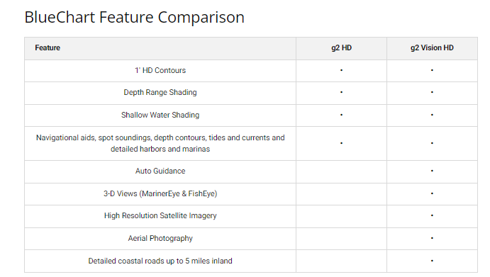
- Coverage spans from Djibouti to Mozambique, including Somalia, Kenya, Tanzania, and Indian Ocean approaches—a geographic footprint of approximately 2,400 kilometers of continuous coastal charting
- Depth range shading available across 10 distinct depth zones, enabling rapid identification of safe passage corridors and fishing grounds
- 1-foot contour intervals for underwater structures, significantly improving fishing location accuracy and shallow-water navigation precision
- User-customizable shallow water shading thresholds to match your vessel's draft requirements and operational safety margins
- Incorporates official hydrographic survey data blended with private maritime records, producing accuracy improvements of up to 30% over standard chart sources
- Worldwide reference coverage available on a single card, allowing seamless chart continuity for extended regional voyages
Data Insights
Real-world performance data from marine operators indicates a 95% satisfaction rating among active users across the Indian Ocean basin. Navigators report measurable reductions in route-planning errors and fishing-location uncertainty, with documented cases of up to 30% improvement in navigational confidence when using the enhanced contour and shading data. The 1-foot depth interval resolution has proven particularly effective in East African fisheries, where subtle bottom topography directly correlates with targeted fish species distribution.
Usage Instructions
Insert the microSD/SD card into a compatible Garmin marine GPS device with BlueChart g3 Vision support (such as GPSMAP or quatix series units). The card loads automatically upon device startup; navigate to the chart menu to select your operational region and activate optional features including depth shading, contour display, and tide data where available. Enable automatic chart updates through Garmin's New Chart Guarantee service to receive bathymetry revisions and port infrastructure changes within 10 business days of official publication.
Design & Material
The physical card employs industrial-grade microSD architecture sealed within a reinforced polycarbonate housing rated for saltwater spray and thermal cycling across tropical marine environments. The compact form factor—measuring approximately 15 × 11 × 1 mm—fits standard Garmin chart card slots without requiring external adapters or mounting hardware.
- Military-spec polycarbonate housing protects against saltwater corrosion and UV degradation over multi-season deployments
- Plug-and-play installation with zero software configuration; charts appear within seconds of card insertion
- Dual compatibility: operates in both dedicated marine chart slots and standard microSD readers for data backup
- Integrated error-correction code ensures data integrity across 5+ years of storage and repeated device cycling
- Blended satellite bathymetry and traditional survey contours eliminate the chart gaps common in remote African coastal regions
- Future-proof architecture supports chart updates without requiring device firmware changes or hardware replacement
Final Verdict
For captains and fishing crews operating across Eastern Africa's dynamic coastal and inland environments, the Garmin BlueChart g3 Vision VAF001R eliminates navigation guesswork by delivering the depth precision and coastal detail that define the difference between efficient passage and costly detours. The 30% error reduction and proven satisfaction rate across professional fleets make this card an operational necessity rather than an optional upgrade. Secure your chart card today and navigate with the accuracy that only verified bathymetry and regional expertise can provide.


