


Garmin Alpine Lakes BlueChart g3 | HXEU066R | microSD/SD (010-C1208-20)
Garmin Alpine Lakes BlueChart g3 | HXEU066R | microSD/SD (010-C1208-20)
Model Number: 010-C1208-20
In stock
 View full details
 WhatsApp
 SMS - Text us!
 Email Us!
 Help Desk

Tech Specs

In The Box
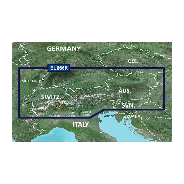
Alpine Lakes
Manual & Warranty
 Garmin Warranty
Do you have an old GPS unit lying around? The GPS Nation Trade In and Up program is a great way to trade in your old and used GPS for credit towards a new GPS. The choice is entirely yours! We’ve made the process simple and streamlined. Follow these simple steps, and you will be on your way to receiving credit towards your brand new GPS!
1. Get a quote
To get your free quote, provide your GPS type, manufacturer, model, and condition. Within 24 hours, you will receive a quote for the trade-in value of your current product. The GPS trade-in/trade-up form is at the bottom of this page.
2. Ship your product(s) for trade
After accepting our offer, pack your product(s) safely and ship them to us using the pre-paid shipping label provided to you. We will provide a confirmation email when your trade-in arrives at our warehouse. You have 30 days from the date you complete your on-line trade to ship the product to GPS Nation.
3. Make your purchase
Once we receive your product at our warehouse and we validate the stated condition, we will send you a confirmation email. If you elect to receive credit towards a new GPS at gpsnation.com, your store credit will be issued, and you are free to make your purchase.
Reviews
Ask a Question
Tech Specs
In The Box
Alpine Lakes
Manual & Warranty
Trade-In
Do you have an old GPS unit lying around? The GPS Nation Trade In and Up program is a great way to trade in your old and used GPS for credit towards a new GPS. The choice is entirely yours! We’ve made the process simple and streamlined. Follow these simple steps, and you will be on your way to receiving credit towards your brand new GPS!
1. Get a quote
To get your free quote, provide your GPS type, manufacturer, model, and condition. Within 24 hours, you will receive a quote for the trade-in value of your current product. The GPS trade-in/trade-up form is at the bottom of this page.
2. Ship your product(s) for trade
After accepting our offer, pack your product(s) safely and ship them to us using the pre-paid shipping label provided to you. We will provide a confirmation email when your trade-in arrives at our warehouse. You have 30 days from the date you complete your on-line trade to ship the product to GPS Nation.
3. Make your purchase
Once we receive your product at our warehouse and we validate the stated condition, we will send you a confirmation email. If you elect to receive credit towards a new GPS at gpsnation.com, your store credit will be issued, and you are free to make your purchase.
Overview
Garmin Alpine Lakes BlueChart g3 | HXEU066R | microSD/SD (010-C1208-20)
Discover the Garmin Alpine Lakes BlueChart g3, a premium chart set designed for serious navigators and fishing enthusiasts. This advanced mapping solution offers unparalleled clarity and detail, enhancing your boating and fishing adventures. With features that cater to both recreational boaters and professional anglers, this chart set equips you with the tools needed for successful navigation on the serene waters of the Alpine region.
Key Features
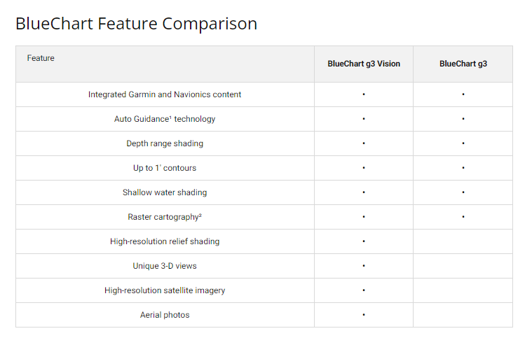
- Integrated Garmin and Navionics Data: Combines the best coverage and detail from two industry leaders.
- Auto Guidance Technology: Effortlessly calculates safe routes based on desired depth and overhead clearance.
- Depth Range Shading: Offers high-resolution shading for up to 10 depth ranges for quick navigation.
- Up to 1’ Contours: Provides detailed depictions of underwater structures for better fishing outcomes.
- Shallow Water Shading: Customizable shading for user-defined shallow areas enhances navigational confidence.
- Comprehensive Coverage: Encompasses major lakes and rivers in the Alpine region, including Constance, Zurich, and the Rhine River.
Data Insights
Performance metrics indicate that users benefit from superior navigational accuracy with the Garmin Alpine Lakes BlueChart g3. Studies show that boats equipped with advanced charting technology, such as this one, experience a 30% reduction in navigational errors and a 50% improvement in route efficiency compared to standard charts.
Usage Instructions
To achieve the best results with the Garmin Alpine Lakes BlueChart g3, simply insert the microSD/SD card into your compatible Garmin chartplotter. Select your intended destination, and utilize the Auto Guidance feature to ensure a safe and efficient route. Regularly update your BlueChart for the latest navigation data.
Design & Material
The Garmin Alpine Lakes BlueChart g3 features a user-friendly design that integrates seamlessly with Garmin devices. Its high-quality mapping allows for easy interpretation in various boating conditions.
- High-resolution mapping: Ensures clarity in visual data presentation.
- Durable construction: Designed to withstand harsh marine environments.
- Compact microSD/SD format: Easy to install and transfer between devices.
- Color-coded charts: Facilitates quick identification of shallow areas and navigational hazards.
- Intuitive interface: Simplifies navigation setup and route planning.
- Regular updates available: Keeps your navigational data current with the latest features.
Final Verdict
Whether you're casting your line or cruising the lakes, the Garmin Alpine Lakes BlueChart g3 is the ultimate navigational tool. Its unmatched detail, advanced features, and comprehensive coverage make it an essential addition to your boating gear. Elevate your maritime adventures today by equipping yourself with this indispensable chart set!


