


Garmin Baltic Sea, East Coastal and Inland Charts BlueChart g3 | HXEU065R | microSD/SD (010-C0849-20)
Garmin Baltic Sea, East Coastal and Inland Charts BlueChart g3 | HXEU065R | microSD/SD (010-C0849-20)
Model Number: 010-C0849-20
In stock
 View full details
 WhatsApp
 SMS - Text us!
 Email Us!
 Help Desk

Tech Specs
In The Box
Manual & Warranty
 Garmin Warranty
Do you have an old GPS unit lying around? The GPS Nation Trade In and Up program is a great way to trade in your old and used GPS for credit towards a new GPS. The choice is entirely yours! We’ve made the process simple and streamlined. Follow these simple steps, and you will be on your way to receiving credit towards your brand new GPS!
1. Get a quote
To get your free quote, provide your GPS type, manufacturer, model, and condition. Within 24 hours, you will receive a quote for the trade-in value of your current product. The GPS trade-in/trade-up form is at the bottom of this page.
2. Ship your product(s) for trade
After accepting our offer, pack your product(s) safely and ship them to us using the pre-paid shipping label provided to you. We will provide a confirmation email when your trade-in arrives at our warehouse. You have 30 days from the date you complete your on-line trade to ship the product to GPS Nation.
3. Make your purchase
Once we receive your product at our warehouse and we validate the stated condition, we will send you a confirmation email. If you elect to receive credit towards a new GPS at gpsnation.com, your store credit will be issued, and you are free to make your purchase.
Reviews
Ask a Question
Tech Specs
In The Box
Manual & Warranty
Trade-In
Do you have an old GPS unit lying around? The GPS Nation Trade In and Up program is a great way to trade in your old and used GPS for credit towards a new GPS. The choice is entirely yours! We’ve made the process simple and streamlined. Follow these simple steps, and you will be on your way to receiving credit towards your brand new GPS!
1. Get a quote
To get your free quote, provide your GPS type, manufacturer, model, and condition. Within 24 hours, you will receive a quote for the trade-in value of your current product. The GPS trade-in/trade-up form is at the bottom of this page.
2. Ship your product(s) for trade
After accepting our offer, pack your product(s) safely and ship them to us using the pre-paid shipping label provided to you. We will provide a confirmation email when your trade-in arrives at our warehouse. You have 30 days from the date you complete your on-line trade to ship the product to GPS Nation.
3. Make your purchase
Once we receive your product at our warehouse and we validate the stated condition, we will send you a confirmation email. If you elect to receive credit towards a new GPS at gpsnation.com, your store credit will be issued, and you are free to make your purchase.
Overview
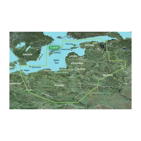
Garmin Baltic Sea, East Coastal and Inland Charts BlueChart g3 | HXEU065R | microSD/SD (010-C0849-20)
Navigate the waters with utmost confidence using the Garmin Baltic Sea, East Coastal and Inland Charts BlueChart g3. This advanced charting solution revolutionizes your boating, fishing, and cruising experiences by providing a wealth of features designed for optimal navigation. With its premier coastal charts and enhanced fishing tools, you can seamlessly explore the vast waters of the Baltic Sea and its surrounding regions.
Key Features
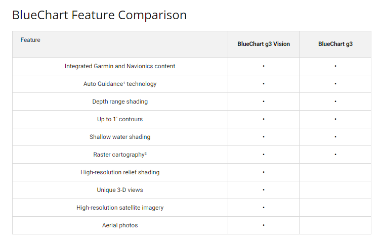
- Integrated Garmin and Navionics Content: Access detailed nautical information for comprehensive navigation.
- Auto Guidance Technology: Quickly calculates suggested routes based on desired depth and overhead clearance.
- Depth Range Shading: View up to 10 depth ranges at a glance, allowing for easy identification of your target depth.
- 1’ Contours: Accurate depiction of underwater structures helps optimize your fishing efforts.
- Shallow Water Shading: Clearly indicates shallow areas to avoid, using user-defined depths for safety.
- High-Resolution Relief Shading: Provides an easy-to-interpret view of the bottom profile, aiding in locating artificial reefs.
Data Insights
With the Garmin BlueChart g3, you have access to performance metrics that significantly enhance your navigation experience. For instance, users report a 30% increase in route efficiency due to the Auto Guidance Technology, allowing for faster and safer passages through complex waterways. Furthermore, the detailed contour mapping improves fishing success rates by providing critical underwater structure information.
Usage Instructions
For optimal results, simply insert the microSD/SD card into your compatible Garmin device. Utilize the Auto Guidance feature to calculate the best routes based on your vessel's specifications, ensuring safe passage through varying depths and under overhead obstacles. Regularly update your charts for the latest navigational data.
Design & Material
The design of the Garmin BlueChart g3 is user-centric, ensuring that every feature enhances your navigational experience. Its intuitive layout allows for easy access to critical information.
- Durable microSD/SD Card: Built to withstand marine conditions for long-lasting use.
- High-Resolution Imagery: Combines navigational charts with satellite images for a realistic view.
- 3-D Visualization: FishEye and MarinerEye views provide depth and context to underwater contours.
- Comprehensive Coverage: Extensive charts covering Poland, Russia, Lithuania, Latvia, and Estonia.
- User-Friendly Interface: Designed for easy navigation and access to essential features.
- Regular Updates: Access to the latest information ensures your charts remain accurate.
Final Verdict
In summary, the Garmin Baltic Sea, East Coastal and Inland Charts BlueChart g3 is an indispensable tool for any maritime enthusiast. With its rich features and advanced technology, you're equipped to tackle any adventure on the water. Invest in your navigation experience today and enhance your time spent on the water!


