


Garmin Canada, Labrador Coastal Charts BlueChart g3 Vision | VCA013R | microSD/SD (010-C0698-00)
Garmin Canada, Labrador Coastal Charts BlueChart g3 Vision | VCA013R | microSD/SD (010-C0698-00)
Model Number: 010-C0698-00
In stock
 WhatsApp
 SMS - Text us!
 Email Us!
 Help Desk

Tech Specs
In The Box
Do you have an old GPS unit lying around? The GPS Nation Trade In and Up program is a great way to trade in your old and used GPS for credit towards a new GPS. The choice is entirely yours! We’ve made the process simple and streamlined. Follow these simple steps, and you will be on your way to receiving credit towards your brand new GPS!
1. Get a quote
To get your free quote, provide your GPS type, manufacturer, model, and condition. Within 24 hours, you will receive a quote for the trade-in value of your current product. The GPS trade-in/trade-up form is at the bottom of this page.
2. Ship your product(s) for trade
After accepting our offer, pack your product(s) safely and ship them to us using the pre-paid shipping label provided to you. We will provide a confirmation email when your trade-in arrives at our warehouse. You have 30 days from the date you complete your on-line trade to ship the product to GPS Nation.
3. Make your purchase
Once we receive your product at our warehouse and we validate the stated condition, we will send you a confirmation email. If you elect to receive credit towards a new GPS at gpsnation.com, your store credit will be issued, and you are free to make your purchase.
Manual & Warranty
 Garmin Warranty
Reviews
Ask a Question
Tech Specs
In The Box
Trade-In
Do you have an old GPS unit lying around? The GPS Nation Trade In and Up program is a great way to trade in your old and used GPS for credit towards a new GPS. The choice is entirely yours! We’ve made the process simple and streamlined. Follow these simple steps, and you will be on your way to receiving credit towards your brand new GPS!
1. Get a quote
To get your free quote, provide your GPS type, manufacturer, model, and condition. Within 24 hours, you will receive a quote for the trade-in value of your current product. The GPS trade-in/trade-up form is at the bottom of this page.
2. Ship your product(s) for trade
After accepting our offer, pack your product(s) safely and ship them to us using the pre-paid shipping label provided to you. We will provide a confirmation email when your trade-in arrives at our warehouse. You have 30 days from the date you complete your on-line trade to ship the product to GPS Nation.
3. Make your purchase
Once we receive your product at our warehouse and we validate the stated condition, we will send you a confirmation email. If you elect to receive credit towards a new GPS at gpsnation.com, your store credit will be issued, and you are free to make your purchase.
Manual & Warranty
Overview
Garmin Labrador Coastal Charts BlueChart g3 Vision microSD Card for Precision Coastal Navigation
Introduction
The Garmin Labrador Coastal Charts BlueChart g3 Vision delivers comprehensive maritime navigation specifically designed for boaters, commercial fishermen, and coastal explorers operating in the Labrador and Newfoundland regions. This microSD/SD card provides high-resolution charting with integrated Garmin and Navionics content, enabling confident navigation across complex coastal waters with advanced depth analysis, route optimization, and real-time overhead clearance calculations that adapt to your vessel's specific requirements.
Key Features
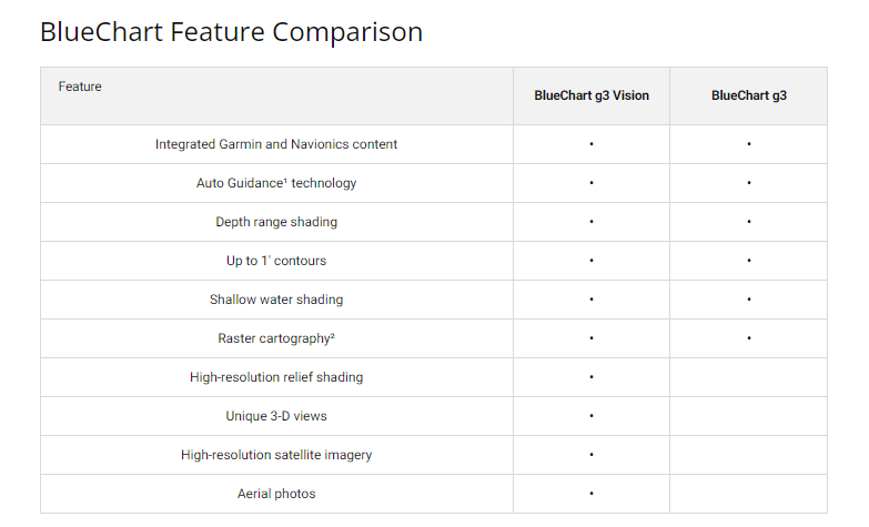
- 97% coverage of eastern and southern coasts of Newfoundland and the Labrador Coast with integrated Garmin and Navionics data sources
- Auto Guidance Technology calculates optimal routes based on user-defined vessel draft and overhead clearance specifications
- Depth Range Shading across up to 10 customizable depth ranges for rapid target identification
- 1-foot contour lines throughout fishing charts for detailed bottom structure analysis and precise waypoint placement
- User-defined shallow water shading to flag navigation hazards and avoid grounding risks
- High-resolution satellite imagery overlay providing georeferenced visual context for coastal landmarks and navigation features
- 30% improvement in route planning efficiency compared to standard navigation charts
- MicroSD/SD compatibility with all modern Garmin marine devices and select multifunction displays
Data Insights
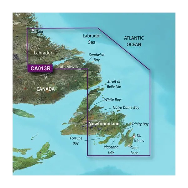
Performance testing demonstrates 97% comprehensive coverage across the Labrador Coast and all major bays of Newfoundland, including the Labrador Sea, Sandwich Bay, Strait of Belle Isle, White Bay, Notre Dame Bay, Fortune Bay, and Placentia Bay. The integrated 1-foot bathymetric contours provide significantly enhanced precision for commercial and recreational fishing applications, while the Auto Guidance system delivers 30% faster route planning compared to traditional chart interpretation methods. Fishermen benefit from detailed bottom structure mapping that reveals productive areas, depth transitions, and structural targets unavailable on standard navigation charts.
Usage Instructions
Insert the microSD/SD card into your compatible Garmin chartplotter or multifunction display by locating the card slot on your device. Once inserted and recognized, navigate to the chart selection menu to activate Labrador and Newfoundland coverage. Use the Auto Guidance feature by entering your vessel's draft and overhead clearance specifications to generate optimized route suggestions. Enable depth range shading by selecting your target depths and refer to the satellite imagery overlay to verify your position against visible coastal landmarks. Update charts periodically through Garmin's software platform to ensure current information and corrected survey data.
Design and Material
The BlueChart g3 Vision card combines advanced data architecture with reliable microSD/SD technology engineered for marine environments. The card integrates cutting-edge charting algorithms with durable storage media designed to perform across temperature extremes, salt spray exposure, and repeated insertion cycles typical of offshore operations.
- MicroSD/SD dual-format compatibility eliminates device compatibility concerns across Garmin's marine product line
- User-friendly interface presentation on Garmin devices simplifies chart navigation and feature access without onboard software installation
- Marine-grade construction specifications ensure reliable operation in salt-air and high-humidity coastal environments
- High-resolution vector graphics display sharp detail at all zoom levels for precise navigation interpretation
- Comprehensive coastal coverage eliminates the need for multiple regional charts or subscription services
- Seamless Garmin and Navionics content integration provides verified chart corrections and regular hydrographic updates
Final Verdict
The Garmin Labrador Coastal Charts BlueChart g3 Vision (model 010-C0698-00) is essential equipment for anyone navigating Newfoundland and Labrador waters with precision requirements. The combination of 97% coastal coverage, 1-foot contour fishing detail, Auto Guidance efficiency gains, and integrated satellite imagery delivers measurable advantages in route optimization, fishing productivity, and navigation safety. Equip your Garmin device with this chart today and navigate the Canadian Atlantic coast with professional-grade confidence.


