


Garmin GPSMAP 722 (010-01738-00)
Garmin GPSMAP 722 (010-01738-00)
Model Number: 010-01738-00
Out of stock
 WhatsApp
 SMS - Text us!
 Email Us!
 Help Desk



Tech Specs
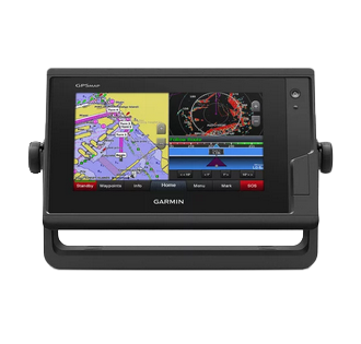
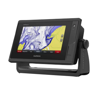
Garmin GPSMAP 722 7-Inch Marine Touchscreen Chartplotter with 10 Hz GPS
Introduction
The Garmin GPSMAP 722 (model 010-01738-00) is a 7-inch marine chartplotter built for navigators who demand accuracy and speed in dynamic water conditions. Its 10 Hz GPS and GLONASS receiver updates position and heading 10 times per second—a tenfold improvement over standard 1 Hz systems—making it ideal for racing fleets, fishing operations, and serious cruisers where real-time responsiveness matters. The compact touchscreen design integrates seamlessly into tight boat dashboards while delivering the performance and connectivity needed for modern marine navigation.
Key Features
- 7-inch high-brightness touchscreen with sunlight-readable display for chart viewing and menu navigation
- 10 Hz GPS and GLONASS receiver providing position updates 10 times per second for enhanced accuracy
- 5,000-waypoint storage capacity for recording and recalling critical navigation points
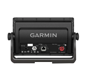
- NMEA 2000 network compatibility for integration with marine instruments, autopilots, and external sensors
- Built-in Wi-Fi connectivity for pairing with Garmin mobile apps and ActiveCaptain community features
- Expandable microSD card memory supporting premium chart options including LakeVü HD Ultra and BlueChart g2 Vision HD
- SailAssist pre-race tools with synchronized race timer, enhanced wind data, and starting line guidance
- Weatherproof marine-grade construction designed to withstand saltwater exposure and harsh conditions
Data Insights
The 10 Hz update rate on the GPSMAP 722 delivers positioning information at speeds significantly faster than conventional marine GPS units operating at 1 Hz refresh rates. This performance advantage is particularly valuable during racing maneuvers, fish-marking operations, and precision docking in congested anchorages. The device's dual-band GPS and GLONASS receiver integration improves acquisition time and maintains lock in challenging environments such as narrow channels or areas with partial sky view. Combined with the 5,000-waypoint memory, users can maintain a comprehensive digital record of productive fishing grounds, safe passages, and navigational hazards across multiple seasons.
Usage Instructions
Begin by connecting the GPSMAP 722 to your vessel's power supply and allowing the GPS receiver 2–3 minutes to acquire initial satellite lock. Download the Garmin ActiveCaptain app to your smartphone or tablet and enable Wi-Fi pairing for remote chart updates and community data sharing. Load your preferred chartset via microSD card or wireless transfer. Access SailAssist features from the main menu if you plan to race; configure waypoint categories and mark navigation points during your first few outings. Familiarize yourself with touchscreen gestures—pinch to zoom, drag to pan, and tap to select features—to maximize efficiency while underway. Update charts and software regularly to benefit from corrected bathymetry, new aids-to-navigation, and feature enhancements.
Design & Material
The GPSMAP 722's engineering prioritizes durability and ease of installation in confined marine spaces. Its low-profile bezel and compact form factor occupy minimal panel real estate, while the intuitive touchscreen interface eliminates the need for complex button hierarchies. The unit's rugged construction is purpose-built to tolerate salt spray, UV exposure, and routine deck washdowns without degradation.
- High-strength marine-grade plastic housing engineered for saltwater resistance and UV stability
- Compact 7-inch footprint with integrated mounting bracket for easy installation in tight helm spaces
- Sunlight-readable touchscreen with anti-glare treatment and responsive capacitive inputs for wet-hand operation
- Weatherproof sealed connectors and gasketted access panels prevent water ingress into electronics
- Lightweight design under 3 lbs facilitates straightforward panel mounting without reinforcement requirements
- Stainless steel and powder-coated metal hardware resist corrosion in marine environments
Final Verdict
The Garmin GPSMAP 722 delivers the positioning speed and network connectivity that modern marine operations demand. Its 10 Hz GPS performance, 5,000-waypoint storage, and NMEA 2000 compatibility make it a practical centerpiece for integrated navigation systems on racing yachts, fishing vessels, and cruising powerboats alike. If you navigate complex waters, coordinate with crew or external instruments, or require rapid position updates during critical maneuvers, this chartplotter bridges the gap between consumer-grade units and higher-end systems. Choose the GPSMAP 722 to upgrade your helm's situational awareness and command the water with confidence.
In The Box
- GPSMAP 722 chartplotter
- Power cable
- Bail mount kit with knobs
- Flush mount kit with gasket
- Protective cover
- Trim piece snap covers
- Documentation
Do you have an old GPS unit lying around? The GPS Nation Trade In and Up program is a great way to trade in your old and used GPS for credit towards a new GPS. The choice is entirely yours! We’ve made the process simple and streamlined. Follow these simple steps, and you will be on your way to receiving credit towards your brand new GPS!
1. Get a quote
To get your free quote, provide your GPS type, manufacturer, model, and condition. Within 24 hours, you will receive a quote for the trade-in value of your current product. The GPS trade-in/trade-up form is at the bottom of this page.
2. Ship your product(s) for trade
After accepting our offer, pack your product(s) safely and ship them to us using the pre-paid shipping label provided to you. We will provide a confirmation email when your trade-in arrives at our warehouse. You have 30 days from the date you complete your on-line trade to ship the product to GPS Nation.
3. Make your purchase
Once we receive your product at our warehouse and we validate the stated condition, we will send you a confirmation email. If you elect to receive credit towards a new GPS at gpsnation.com, your store credit will be issued, and you are free to make your purchase.
Manual & Warranty
 Garmin Warranty
Reviews
Ask a Question
Tech Specs
Garmin GPSMAP 722 7-Inch Marine Touchscreen Chartplotter with 10 Hz GPS
Introduction
The Garmin GPSMAP 722 (model 010-01738-00) is a 7-inch marine chartplotter built for navigators who demand accuracy and speed in dynamic water conditions. Its 10 Hz GPS and GLONASS receiver updates position and heading 10 times per second—a tenfold improvement over standard 1 Hz systems—making it ideal for racing fleets, fishing operations, and serious cruisers where real-time responsiveness matters. The compact touchscreen design integrates seamlessly into tight boat dashboards while delivering the performance and connectivity needed for modern marine navigation.
Key Features
- 7-inch high-brightness touchscreen with sunlight-readable display for chart viewing and menu navigation
- 10 Hz GPS and GLONASS receiver providing position updates 10 times per second for enhanced accuracy
- 5,000-waypoint storage capacity for recording and recalling critical navigation points
- NMEA 2000 network compatibility for integration with marine instruments, autopilots, and external sensors
- Built-in Wi-Fi connectivity for pairing with Garmin mobile apps and ActiveCaptain community features
- Expandable microSD card memory supporting premium chart options including LakeVü HD Ultra and BlueChart g2 Vision HD
- SailAssist pre-race tools with synchronized race timer, enhanced wind data, and starting line guidance
- Weatherproof marine-grade construction designed to withstand saltwater exposure and harsh conditions
Data Insights
The 10 Hz update rate on the GPSMAP 722 delivers positioning information at speeds significantly faster than conventional marine GPS units operating at 1 Hz refresh rates. This performance advantage is particularly valuable during racing maneuvers, fish-marking operations, and precision docking in congested anchorages. The device's dual-band GPS and GLONASS receiver integration improves acquisition time and maintains lock in challenging environments such as narrow channels or areas with partial sky view. Combined with the 5,000-waypoint memory, users can maintain a comprehensive digital record of productive fishing grounds, safe passages, and navigational hazards across multiple seasons.
Usage Instructions
Begin by connecting the GPSMAP 722 to your vessel's power supply and allowing the GPS receiver 2–3 minutes to acquire initial satellite lock. Download the Garmin ActiveCaptain app to your smartphone or tablet and enable Wi-Fi pairing for remote chart updates and community data sharing. Load your preferred chartset via microSD card or wireless transfer. Access SailAssist features from the main menu if you plan to race; configure waypoint categories and mark navigation points during your first few outings. Familiarize yourself with touchscreen gestures—pinch to zoom, drag to pan, and tap to select features—to maximize efficiency while underway. Update charts and software regularly to benefit from corrected bathymetry, new aids-to-navigation, and feature enhancements.
Design & Material
The GPSMAP 722's engineering prioritizes durability and ease of installation in confined marine spaces. Its low-profile bezel and compact form factor occupy minimal panel real estate, while the intuitive touchscreen interface eliminates the need for complex button hierarchies. The unit's rugged construction is purpose-built to tolerate salt spray, UV exposure, and routine deck washdowns without degradation.
- High-strength marine-grade plastic housing engineered for saltwater resistance and UV stability
- Compact 7-inch footprint with integrated mounting bracket for easy installation in tight helm spaces
- Sunlight-readable touchscreen with anti-glare treatment and responsive capacitive inputs for wet-hand operation
- Weatherproof sealed connectors and gasketted access panels prevent water ingress into electronics
- Lightweight design under 3 lbs facilitates straightforward panel mounting without reinforcement requirements
- Stainless steel and powder-coated metal hardware resist corrosion in marine environments
Final Verdict
The Garmin GPSMAP 722 delivers the positioning speed and network connectivity that modern marine operations demand. Its 10 Hz GPS performance, 5,000-waypoint storage, and NMEA 2000 compatibility make it a practical centerpiece for integrated navigation systems on racing yachts, fishing vessels, and cruising powerboats alike. If you navigate complex waters, coordinate with crew or external instruments, or require rapid position updates during critical maneuvers, this chartplotter bridges the gap between consumer-grade units and higher-end systems. Choose the GPSMAP 722 to upgrade your helm's situational awareness and command the water with confidence.
In The Box
- GPSMAP 722 chartplotter
- Power cable
- Bail mount kit with knobs
- Flush mount kit with gasket
- Protective cover
- Trim piece snap covers
- Documentation
Trade-In
Do you have an old GPS unit lying around? The GPS Nation Trade In and Up program is a great way to trade in your old and used GPS for credit towards a new GPS. The choice is entirely yours! We’ve made the process simple and streamlined. Follow these simple steps, and you will be on your way to receiving credit towards your brand new GPS!
1. Get a quote
To get your free quote, provide your GPS type, manufacturer, model, and condition. Within 24 hours, you will receive a quote for the trade-in value of your current product. The GPS trade-in/trade-up form is at the bottom of this page.
2. Ship your product(s) for trade
After accepting our offer, pack your product(s) safely and ship them to us using the pre-paid shipping label provided to you. We will provide a confirmation email when your trade-in arrives at our warehouse. You have 30 days from the date you complete your on-line trade to ship the product to GPS Nation.
3. Make your purchase
Once we receive your product at our warehouse and we validate the stated condition, we will send you a confirmation email. If you elect to receive credit towards a new GPS at gpsnation.com, your store credit will be issued, and you are free to make your purchase.
Manual & Warranty
Overview
Garmin GPSMAP 722 7-Inch Marine Touchscreen Chartplotter with 10 Hz GPS
Introduction
The Garmin GPSMAP 722 (model 010-01738-00) is a 7-inch marine chartplotter built for navigators who demand accuracy and speed in dynamic water conditions. Its 10 Hz GPS and GLONASS receiver updates position and heading 10 times per second—a tenfold improvement over standard 1 Hz systems—making it ideal for racing fleets, fishing operations, and serious cruisers where real-time responsiveness matters. The compact touchscreen design integrates seamlessly into tight boat dashboards while delivering the performance and connectivity needed for modern marine navigation.
Key Features
- 7-inch high-brightness touchscreen with sunlight-readable display for chart viewing and menu navigation
- 10 Hz GPS and GLONASS receiver providing position updates 10 times per second for enhanced accuracy
- 5,000-waypoint storage capacity for recording and recalling critical navigation points
- NMEA 2000 network compatibility for integration with marine instruments, autopilots, and external sensors
- Built-in Wi-Fi connectivity for pairing with Garmin mobile apps and ActiveCaptain community features
- Expandable microSD card memory supporting premium chart options including LakeVü HD Ultra and BlueChart g2 Vision HD
- SailAssist pre-race tools with synchronized race timer, enhanced wind data, and starting line guidance
- Weatherproof marine-grade construction designed to withstand saltwater exposure and harsh conditions
Data Insights
The 10 Hz update rate on the GPSMAP 722 delivers positioning information at speeds significantly faster than conventional marine GPS units operating at 1 Hz refresh rates. This performance advantage is particularly valuable during racing maneuvers, fish-marking operations, and precision docking in congested anchorages. The device's dual-band GPS and GLONASS receiver integration improves acquisition time and maintains lock in challenging environments such as narrow channels or areas with partial sky view. Combined with the 5,000-waypoint memory, users can maintain a comprehensive digital record of productive fishing grounds, safe passages, and navigational hazards across multiple seasons.
Usage Instructions
Begin by connecting the GPSMAP 722 to your vessel's power supply and allowing the GPS receiver 2–3 minutes to acquire initial satellite lock. Download the Garmin ActiveCaptain app to your smartphone or tablet and enable Wi-Fi pairing for remote chart updates and community data sharing. Load your preferred chartset via microSD card or wireless transfer. Access SailAssist features from the main menu if you plan to race; configure waypoint categories and mark navigation points during your first few outings. Familiarize yourself with touchscreen gestures—pinch to zoom, drag to pan, and tap to select features—to maximize efficiency while underway. Update charts and software regularly to benefit from corrected bathymetry, new aids-to-navigation, and feature enhancements.
Design & Material
The GPSMAP 722's engineering prioritizes durability and ease of installation in confined marine spaces. Its low-profile bezel and compact form factor occupy minimal panel real estate, while the intuitive touchscreen interface eliminates the need for complex button hierarchies. The unit's rugged construction is purpose-built to tolerate salt spray, UV exposure, and routine deck washdowns without degradation.
- High-strength marine-grade plastic housing engineered for saltwater resistance and UV stability
- Compact 7-inch footprint with integrated mounting bracket for easy installation in tight helm spaces
- Sunlight-readable touchscreen with anti-glare treatment and responsive capacitive inputs for wet-hand operation
- Weatherproof sealed connectors and gasketted access panels prevent water ingress into electronics
- Lightweight design under 3 lbs facilitates straightforward panel mounting without reinforcement requirements
- Stainless steel and powder-coated metal hardware resist corrosion in marine environments
Final Verdict
The Garmin GPSMAP 722 delivers the positioning speed and network connectivity that modern marine operations demand. Its 10 Hz GPS performance, 5,000-waypoint storage, and NMEA 2000 compatibility make it a practical centerpiece for integrated navigation systems on racing yachts, fishing vessels, and cruising powerboats alike. If you navigate complex waters, coordinate with crew or external instruments, or require rapid position updates during critical maneuvers, this chartplotter bridges the gap between consumer-grade units and higher-end systems. Choose the GPSMAP 722 to upgrade your helm's situational awareness and command the water with confidence.


