


 WhatsApp
 SMS - Text us!
 Email Us!
 Help Desk
- GPSMAP 7616 preloaded with BlueChart® g2 and LakeVü HD coastal maps
- Power/data cable
- NMEA 2000® drop cable
- T-connector
- Flush mount kit
- Protective cover
- Documentation
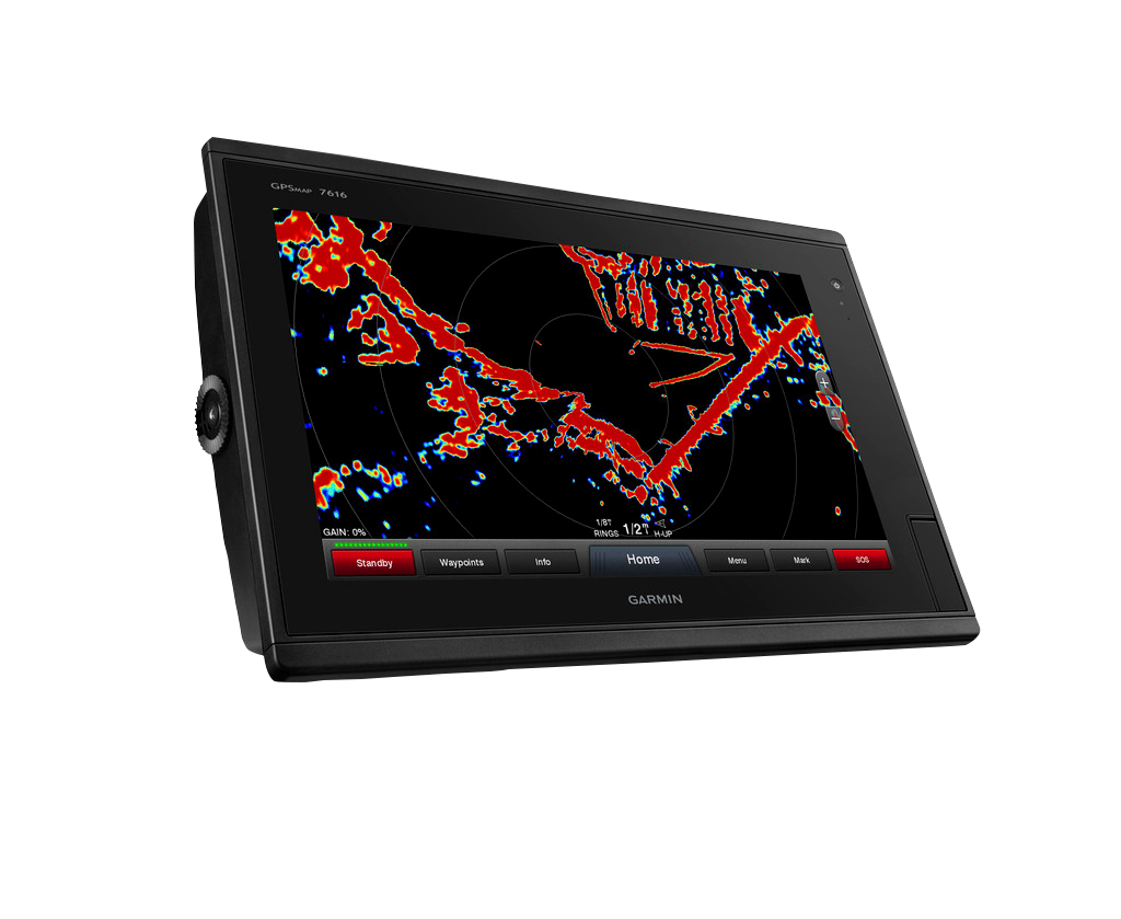
Garmin GPSMAP 7616 (010-01402-01)
Garmin GPSMAP 7616 (010-01402-01)
Model Number: 010-01402-01
Out of stock
Regular price
$6,544.99
Sale price
$6,544.99
Regular price
Unit price
per
 View full details

Tech Specs
Garmin GPSMAP 7616 (010-01402-01) - Elevate Your Navigation Experience
Discover unmatched precision and reliability on the water with the Garmin GPSMAP 7616. This state-of-the-art chartplotter is engineered to meet the demands of avid sailors and mariners alike, offering unparalleled navigation capabilities that ensure you stay informed and connected during your adventures. With advanced mapping features and real-time data at your fingertips, the GPSMAP 7616 is designed to enhance your boating experience while prioritizing safety and efficiency.
Key Features
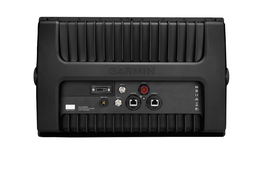
- Full-Network Compatibility: Seamlessly integrate radar, autopilot, sensors, and remote sonar modules for a customized setup.
- Fast GPS Refresh Rate: With a 10 Hz GPS/GLONASS refresh rate, your position and heading are updated 10 times per second.
- Preloaded Maps: Enjoy detailed BlueChart g2 and LakeVü HD maps covering thousands of U.S. lakes and coastal areas.
- Advanced Sailing Features: Utilize tools like laylines and true wind data to elevate your sailing performance.
- Expandable Memory: Two SD card slots allow for easy map upgrades and memory expansion.
- Panoptix™ Technology: View real-time sonar images with Panoptix Down and Forward transducers for 3D underwater visualization.
Data Insights
The Garmin GPSMAP 7616 offers a fast refresh rate that enhances situational awareness, allowing users to make informed decisions on the water. With a 10 Hz update rate, you'll experience smoother navigation compared to traditional devices that may refresh every few seconds. This feature, coupled with advanced mapping capabilities, significantly boosts safety and planning accuracy, making it a valuable tool for both seasoned and novice mariners.
Usage Instructions
For optimal results, simply mount the Garmin GPSMAP 7616 in a location with a clear view of the horizon. Power on the device, and utilize the touch screen to navigate through the preloaded maps and features. Regularly update your SD cards to ensure you have the latest nautical charts and data for safe navigation.
Design & Material
The Garmin GPSMAP 7616 boasts a sleek, user-friendly design that integrates seamlessly into any marine environment. The high-resolution display provides clear visuals even in bright sunlight, ensuring that you can read navigation data easily.
- Durable Build: Constructed with high-quality marine-grade materials for longevity.
- Intuitive Touchscreen: 16-inch display with a responsive interface for effortless navigation.
- Weather-Resistant: Designed to withstand harsh marine conditions.
- Easy Installation: User-friendly setup process to minimize installation time.
- Multiple Viewing Angles: Enhanced visibility from various positions on the boat.
- Modern Aesthetics: Sleek design that complements any boat's interior.
Final Verdict
Transform your boating experience and navigate with confidence using the Garmin GPSMAP 7616. With cutting-edge features, exceptional performance metrics, and a durable design, this chartplotter is a must-have for anyone serious about their time on the water. Don’t miss out on the opportunity to enhance your maritime adventures. Upgrade to the Garmin GPSMAP 7616 today!
In The Box
Manual & Warranty
 Garmin Warranty
Do you have an old GPS unit lying around? The GPS Nation Trade In and Up program is a great way to trade in your old and used GPS for credit towards a new GPS. The choice is entirely yours! We’ve made the process simple and streamlined. Follow these simple steps, and you will be on your way to receiving credit towards your brand new GPS!
1. Get a quote
To get your free quote, provide your GPS type, manufacturer, model, and condition. Within 24 hours, you will receive a quote for the trade-in value of your current product. The GPS trade-in/trade-up form is at the bottom of this page.
2. Ship your product(s) for trade
After accepting our offer, pack your product(s) safely and ship them to us using the pre-paid shipping label provided to you. We will provide a confirmation email when your trade-in arrives at our warehouse. You have 30 days from the date you complete your on-line trade to ship the product to GPS Nation.
3. Make your purchase
Once we receive your product at our warehouse and we validate the stated condition, we will send you a confirmation email. If you elect to receive credit towards a new GPS at gpsnation.com, your store credit will be issued, and you are free to make your purchase.
Reviews
Ask a Question
Tech Specs
Garmin GPSMAP 7616 (010-01402-01) - Elevate Your Navigation Experience
Discover unmatched precision and reliability on the water with the Garmin GPSMAP 7616. This state-of-the-art chartplotter is engineered to meet the demands of avid sailors and mariners alike, offering unparalleled navigation capabilities that ensure you stay informed and connected during your adventures. With advanced mapping features and real-time data at your fingertips, the GPSMAP 7616 is designed to enhance your boating experience while prioritizing safety and efficiency.
Key Features
- Full-Network Compatibility: Seamlessly integrate radar, autopilot, sensors, and remote sonar modules for a customized setup.
- Fast GPS Refresh Rate: With a 10 Hz GPS/GLONASS refresh rate, your position and heading are updated 10 times per second.
- Preloaded Maps: Enjoy detailed BlueChart g2 and LakeVü HD maps covering thousands of U.S. lakes and coastal areas.
- Advanced Sailing Features: Utilize tools like laylines and true wind data to elevate your sailing performance.
- Expandable Memory: Two SD card slots allow for easy map upgrades and memory expansion.
- Panoptix™ Technology: View real-time sonar images with Panoptix Down and Forward transducers for 3D underwater visualization.
Data Insights
The Garmin GPSMAP 7616 offers a fast refresh rate that enhances situational awareness, allowing users to make informed decisions on the water. With a 10 Hz update rate, you'll experience smoother navigation compared to traditional devices that may refresh every few seconds. This feature, coupled with advanced mapping capabilities, significantly boosts safety and planning accuracy, making it a valuable tool for both seasoned and novice mariners.
Usage Instructions
For optimal results, simply mount the Garmin GPSMAP 7616 in a location with a clear view of the horizon. Power on the device, and utilize the touch screen to navigate through the preloaded maps and features. Regularly update your SD cards to ensure you have the latest nautical charts and data for safe navigation.
Design & Material
The Garmin GPSMAP 7616 boasts a sleek, user-friendly design that integrates seamlessly into any marine environment. The high-resolution display provides clear visuals even in bright sunlight, ensuring that you can read navigation data easily.
- Durable Build: Constructed with high-quality marine-grade materials for longevity.
- Intuitive Touchscreen: 16-inch display with a responsive interface for effortless navigation.
- Weather-Resistant: Designed to withstand harsh marine conditions.
- Easy Installation: User-friendly setup process to minimize installation time.
- Multiple Viewing Angles: Enhanced visibility from various positions on the boat.
- Modern Aesthetics: Sleek design that complements any boat's interior.
Final Verdict
Transform your boating experience and navigate with confidence using the Garmin GPSMAP 7616. With cutting-edge features, exceptional performance metrics, and a durable design, this chartplotter is a must-have for anyone serious about their time on the water. Don’t miss out on the opportunity to enhance your maritime adventures. Upgrade to the Garmin GPSMAP 7616 today!
In The Box
- GPSMAP 7616 preloaded with BlueChart® g2 and LakeVü HD coastal maps
- Power/data cable
- NMEA 2000® drop cable
- T-connector
- Flush mount kit
- Protective cover
- Documentation
Manual & Warranty
Trade-In
Do you have an old GPS unit lying around? The GPS Nation Trade In and Up program is a great way to trade in your old and used GPS for credit towards a new GPS. The choice is entirely yours! We’ve made the process simple and streamlined. Follow these simple steps, and you will be on your way to receiving credit towards your brand new GPS!
1. Get a quote
To get your free quote, provide your GPS type, manufacturer, model, and condition. Within 24 hours, you will receive a quote for the trade-in value of your current product. The GPS trade-in/trade-up form is at the bottom of this page.
2. Ship your product(s) for trade
After accepting our offer, pack your product(s) safely and ship them to us using the pre-paid shipping label provided to you. We will provide a confirmation email when your trade-in arrives at our warehouse. You have 30 days from the date you complete your on-line trade to ship the product to GPS Nation.
3. Make your purchase
Once we receive your product at our warehouse and we validate the stated condition, we will send you a confirmation email. If you elect to receive credit towards a new GPS at gpsnation.com, your store credit will be issued, and you are free to make your purchase.
Overview
Garmin GPSMAP 7616 (010-01402-01) - Elevate Your Navigation Experience
Discover unmatched precision and reliability on the water with the Garmin GPSMAP 7616. This state-of-the-art chartplotter is engineered to meet the demands of avid sailors and mariners alike, offering unparalleled navigation capabilities that ensure you stay informed and connected during your adventures. With advanced mapping features and real-time data at your fingertips, the GPSMAP 7616 is designed to enhance your boating experience while prioritizing safety and efficiency.
Key Features
- Full-Network Compatibility: Seamlessly integrate radar, autopilot, sensors, and remote sonar modules for a customized setup.
- Fast GPS Refresh Rate: With a 10 Hz GPS/GLONASS refresh rate, your position and heading are updated 10 times per second.
- Preloaded Maps: Enjoy detailed BlueChart g2 and LakeVü HD maps covering thousands of U.S. lakes and coastal areas.
- Advanced Sailing Features: Utilize tools like laylines and true wind data to elevate your sailing performance.
- Expandable Memory: Two SD card slots allow for easy map upgrades and memory expansion.
- Panoptix™ Technology: View real-time sonar images with Panoptix Down and Forward transducers for 3D underwater visualization.
Data Insights
The Garmin GPSMAP 7616 offers a fast refresh rate that enhances situational awareness, allowing users to make informed decisions on the water. With a 10 Hz update rate, you'll experience smoother navigation compared to traditional devices that may refresh every few seconds. This feature, coupled with advanced mapping capabilities, significantly boosts safety and planning accuracy, making it a valuable tool for both seasoned and novice mariners.
Usage Instructions
For optimal results, simply mount the Garmin GPSMAP 7616 in a location with a clear view of the horizon. Power on the device, and utilize the touch screen to navigate through the preloaded maps and features. Regularly update your SD cards to ensure you have the latest nautical charts and data for safe navigation.
Design & Material
The Garmin GPSMAP 7616 boasts a sleek, user-friendly design that integrates seamlessly into any marine environment. The high-resolution display provides clear visuals even in bright sunlight, ensuring that you can read navigation data easily.
- Durable Build: Constructed with high-quality marine-grade materials for longevity.
- Intuitive Touchscreen: 16-inch display with a responsive interface for effortless navigation.
- Weather-Resistant: Designed to withstand harsh marine conditions.
- Easy Installation: User-friendly setup process to minimize installation time.
- Multiple Viewing Angles: Enhanced visibility from various positions on the boat.
- Modern Aesthetics: Sleek design that complements any boat's interior.
Final Verdict
Transform your boating experience and navigate with confidence using the Garmin GPSMAP 7616. With cutting-edge features, exceptional performance metrics, and a durable design, this chartplotter is a must-have for anyone serious about their time on the water. Don’t miss out on the opportunity to enhance your maritime adventures. Upgrade to the Garmin GPSMAP 7616 today!


