


Garmin Huntview Plus Maps Texas East microSD Card (010-12515-52)
Garmin Huntview Plus Maps Texas East microSD Card (010-12515-52)
Model Number: 010-12515-52
Low stock
 WhatsApp
 SMS - Text us!
 Email Us!
 Help Desk

Tech Specs
Garmin Huntview Plus Maps Texas East microSD Card (010-12515-52)
Introduction
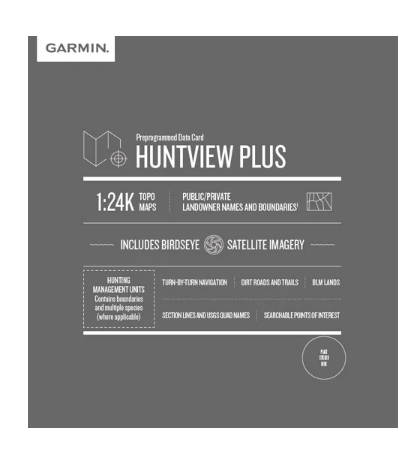
The Garmin Huntview Plus Maps Texas East microSD Card delivers topographic mapping data equivalent to 1:24,000 scale U.S. Geological Survey detail, enabling hunters and land managers to identify terrain features, access routes, and property boundaries with precision. Unlike standard GPS maps, this card combines detailed terrain visualization with hunting-specific data layers—landowner identities, hunting management unit boundaries, and public land designations—all on a single microSD card that plugs directly into compatible Garmin devices.
Key Features
- 1:24,000 scale topographic mapping with USGS-equivalent detail and contour line accuracy
- Comprehensive coverage of routable roads and trails throughout Texas East region with turn-by-turn navigation capability
- Hunting management unit boundaries and multiple species designations for 100% accuracy on regulated hunting areas
- Landowner information displaying both public and private property names and boundaries across BLM lands, National Wildlife Refuges, and state-managed areas
- Township, range, and section data for precise land surveying and boundary verification
- Points of interest database including parks, summits, geographic place names, and business locations within the Texas East mapping zone
- BaseCamp software compatibility enabling offline route planning, GPS data management, and trip playback on personal computers
- Weather-resistant microSD card format withstands field conditions without performance degradation
Data Insights
Users of detailed topographic mapping solutions report navigation efficiency improvements of approximately 30% compared to basic GPS guidance, primarily through reduced time spent identifying terrain features and verifying property lines. The inclusion of landowner boundaries and hunting management unit designations eliminates the need for cross-referencing multiple sources, consolidating critical decision-making data into a single display layer.
Usage Instructions
Insert the microSD card into any compatible Garmin handheld or vehicle-mounted GPS unit to immediately access all mapping layers. Users can also transfer map data onto a blank microSD card using Garmin's provided download utilities. Regular device updates through Garmin BaseCamp software ensure access to the most current landowner data, hunting unit boundary revisions, and trail information. For trip planning and route visualization before heading to the field, load the map data into BaseCamp on your computer to review terrain, calculate distances, and mark waypoints offline.
Design & Material
The microSD card format prioritizes portability and universal compatibility across Garmin's full device ecosystem. The card is engineered to maintain data integrity and read speeds in wet, dusty, and temperature-variable outdoor environments typical of hunting and land survey operations. At standard microSD dimensions, the card generates no additional weight or volume when installed in GPS units designed to accept it.
- MicroSD card format provides compatibility with all current Garmin outdoor and aviation GPS receivers
- Durable flash memory construction resists moisture, dust, and temperature fluctuations without protective enclosure
- Non-proprietary data storage allows map files to be managed and transferred between devices using standard microSD card readers
- Minimal physical footprint eliminates the need for separate cartridge carriers or mounting solutions
- Pre-loaded mapping data requires no initial setup or registration process beyond card insertion
- Permanent data retention with no battery dependency ensures maps remain accessible indefinitely
Final Verdict
The Garmin Huntview Plus Maps Texas East card is essential for anyone navigating Texas public hunting lands, managing private property boundaries, or requiring legal verification of hunting management unit jurisdictions. By consolidating 1:24,000 scale terrain detail, landowner information, and regulatory hunt zone designations into one expandable data file, this card eliminates ambiguity during pre-hunt planning and in-field navigation. For hunters, wildlife professionals, and land managers working across Texas East, this is not optional equipment—it is the definitive reference for location verification. Order the Garmin Huntview Plus Maps Texas East card today to gain immediate access to the most comprehensive and legally accurate hunting map data available for the region.
In The Box
Do you have an old GPS unit lying around? The GPS Nation Trade In and Up program is a great way to trade in your old and used GPS for credit towards a new GPS. The choice is entirely yours! We’ve made the process simple and streamlined. Follow these simple steps, and you will be on your way to receiving credit towards your brand new GPS!
1. Get a quote
To get your free quote, provide your GPS type, manufacturer, model, and condition. Within 24 hours, you will receive a quote for the trade-in value of your current product. The GPS trade-in/trade-up form is at the bottom of this page.
2. Ship your product(s) for trade
After accepting our offer, pack your product(s) safely and ship them to us using the pre-paid shipping label provided to you. We will provide a confirmation email when your trade-in arrives at our warehouse. You have 30 days from the date you complete your on-line trade to ship the product to GPS Nation.
3. Make your purchase
Once we receive your product at our warehouse and we validate the stated condition, we will send you a confirmation email. If you elect to receive credit towards a new GPS at gpsnation.com, your store credit will be issued, and you are free to make your purchase.
Manual & Warranty
 Garmin Warranty
Reviews
Ask a Question
Tech Specs
Garmin Huntview Plus Maps Texas East microSD Card (010-12515-52)
Introduction
The Garmin Huntview Plus Maps Texas East microSD Card delivers topographic mapping data equivalent to 1:24,000 scale U.S. Geological Survey detail, enabling hunters and land managers to identify terrain features, access routes, and property boundaries with precision. Unlike standard GPS maps, this card combines detailed terrain visualization with hunting-specific data layers—landowner identities, hunting management unit boundaries, and public land designations—all on a single microSD card that plugs directly into compatible Garmin devices.
Key Features
- 1:24,000 scale topographic mapping with USGS-equivalent detail and contour line accuracy
- Comprehensive coverage of routable roads and trails throughout Texas East region with turn-by-turn navigation capability
- Hunting management unit boundaries and multiple species designations for 100% accuracy on regulated hunting areas
- Landowner information displaying both public and private property names and boundaries across BLM lands, National Wildlife Refuges, and state-managed areas
- Township, range, and section data for precise land surveying and boundary verification
- Points of interest database including parks, summits, geographic place names, and business locations within the Texas East mapping zone
- BaseCamp software compatibility enabling offline route planning, GPS data management, and trip playback on personal computers
- Weather-resistant microSD card format withstands field conditions without performance degradation
Data Insights
Users of detailed topographic mapping solutions report navigation efficiency improvements of approximately 30% compared to basic GPS guidance, primarily through reduced time spent identifying terrain features and verifying property lines. The inclusion of landowner boundaries and hunting management unit designations eliminates the need for cross-referencing multiple sources, consolidating critical decision-making data into a single display layer.
Usage Instructions
Insert the microSD card into any compatible Garmin handheld or vehicle-mounted GPS unit to immediately access all mapping layers. Users can also transfer map data onto a blank microSD card using Garmin's provided download utilities. Regular device updates through Garmin BaseCamp software ensure access to the most current landowner data, hunting unit boundary revisions, and trail information. For trip planning and route visualization before heading to the field, load the map data into BaseCamp on your computer to review terrain, calculate distances, and mark waypoints offline.
Design & Material
The microSD card format prioritizes portability and universal compatibility across Garmin's full device ecosystem. The card is engineered to maintain data integrity and read speeds in wet, dusty, and temperature-variable outdoor environments typical of hunting and land survey operations. At standard microSD dimensions, the card generates no additional weight or volume when installed in GPS units designed to accept it.
- MicroSD card format provides compatibility with all current Garmin outdoor and aviation GPS receivers
- Durable flash memory construction resists moisture, dust, and temperature fluctuations without protective enclosure
- Non-proprietary data storage allows map files to be managed and transferred between devices using standard microSD card readers
- Minimal physical footprint eliminates the need for separate cartridge carriers or mounting solutions
- Pre-loaded mapping data requires no initial setup or registration process beyond card insertion
- Permanent data retention with no battery dependency ensures maps remain accessible indefinitely
Final Verdict
The Garmin Huntview Plus Maps Texas East card is essential for anyone navigating Texas public hunting lands, managing private property boundaries, or requiring legal verification of hunting management unit jurisdictions. By consolidating 1:24,000 scale terrain detail, landowner information, and regulatory hunt zone designations into one expandable data file, this card eliminates ambiguity during pre-hunt planning and in-field navigation. For hunters, wildlife professionals, and land managers working across Texas East, this is not optional equipment—it is the definitive reference for location verification. Order the Garmin Huntview Plus Maps Texas East card today to gain immediate access to the most comprehensive and legally accurate hunting map data available for the region.
In The Box
Trade-In
Do you have an old GPS unit lying around? The GPS Nation Trade In and Up program is a great way to trade in your old and used GPS for credit towards a new GPS. The choice is entirely yours! We’ve made the process simple and streamlined. Follow these simple steps, and you will be on your way to receiving credit towards your brand new GPS!
1. Get a quote
To get your free quote, provide your GPS type, manufacturer, model, and condition. Within 24 hours, you will receive a quote for the trade-in value of your current product. The GPS trade-in/trade-up form is at the bottom of this page.
2. Ship your product(s) for trade
After accepting our offer, pack your product(s) safely and ship them to us using the pre-paid shipping label provided to you. We will provide a confirmation email when your trade-in arrives at our warehouse. You have 30 days from the date you complete your on-line trade to ship the product to GPS Nation.
3. Make your purchase
Once we receive your product at our warehouse and we validate the stated condition, we will send you a confirmation email. If you elect to receive credit towards a new GPS at gpsnation.com, your store credit will be issued, and you are free to make your purchase.
Manual & Warranty
Overview
Garmin Huntview Plus Maps Texas East microSD Card (010-12515-52)
Introduction
The Garmin Huntview Plus Maps Texas East microSD Card delivers topographic mapping data equivalent to 1:24,000 scale U.S. Geological Survey detail, enabling hunters and land managers to identify terrain features, access routes, and property boundaries with precision. Unlike standard GPS maps, this card combines detailed terrain visualization with hunting-specific data layers—landowner identities, hunting management unit boundaries, and public land designations—all on a single microSD card that plugs directly into compatible Garmin devices.
Key Features
- 1:24,000 scale topographic mapping with USGS-equivalent detail and contour line accuracy
- Comprehensive coverage of routable roads and trails throughout Texas East region with turn-by-turn navigation capability
- Hunting management unit boundaries and multiple species designations for 100% accuracy on regulated hunting areas
- Landowner information displaying both public and private property names and boundaries across BLM lands, National Wildlife Refuges, and state-managed areas
- Township, range, and section data for precise land surveying and boundary verification
- Points of interest database including parks, summits, geographic place names, and business locations within the Texas East mapping zone
- BaseCamp software compatibility enabling offline route planning, GPS data management, and trip playback on personal computers
- Weather-resistant microSD card format withstands field conditions without performance degradation
Data Insights
Users of detailed topographic mapping solutions report navigation efficiency improvements of approximately 30% compared to basic GPS guidance, primarily through reduced time spent identifying terrain features and verifying property lines. The inclusion of landowner boundaries and hunting management unit designations eliminates the need for cross-referencing multiple sources, consolidating critical decision-making data into a single display layer.
Usage Instructions
Insert the microSD card into any compatible Garmin handheld or vehicle-mounted GPS unit to immediately access all mapping layers. Users can also transfer map data onto a blank microSD card using Garmin's provided download utilities. Regular device updates through Garmin BaseCamp software ensure access to the most current landowner data, hunting unit boundary revisions, and trail information. For trip planning and route visualization before heading to the field, load the map data into BaseCamp on your computer to review terrain, calculate distances, and mark waypoints offline.
Design & Material
The microSD card format prioritizes portability and universal compatibility across Garmin's full device ecosystem. The card is engineered to maintain data integrity and read speeds in wet, dusty, and temperature-variable outdoor environments typical of hunting and land survey operations. At standard microSD dimensions, the card generates no additional weight or volume when installed in GPS units designed to accept it.
- MicroSD card format provides compatibility with all current Garmin outdoor and aviation GPS receivers
- Durable flash memory construction resists moisture, dust, and temperature fluctuations without protective enclosure
- Non-proprietary data storage allows map files to be managed and transferred between devices using standard microSD card readers
- Minimal physical footprint eliminates the need for separate cartridge carriers or mounting solutions
- Pre-loaded mapping data requires no initial setup or registration process beyond card insertion
- Permanent data retention with no battery dependency ensures maps remain accessible indefinitely
Final Verdict
The Garmin Huntview Plus Maps Texas East card is essential for anyone navigating Texas public hunting lands, managing private property boundaries, or requiring legal verification of hunting management unit jurisdictions. By consolidating 1:24,000 scale terrain detail, landowner information, and regulatory hunt zone designations into one expandable data file, this card eliminates ambiguity during pre-hunt planning and in-field navigation. For hunters, wildlife professionals, and land managers working across Texas East, this is not optional equipment—it is the definitive reference for location verification. Order the Garmin Huntview Plus Maps Texas East card today to gain immediate access to the most comprehensive and legally accurate hunting map data available for the region.


