


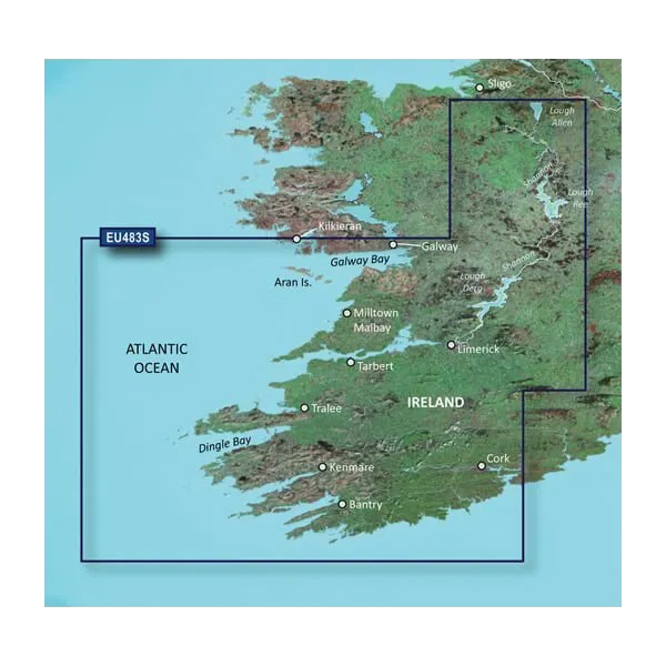
Garmin Ireland, Galway Bay to Cork Charts BlueChart g3 Vision | VEU483S | microSD/SD
Garmin Ireland, Galway Bay to Cork Charts BlueChart g3 Vision | VEU483S | microSD/SD
Model Number: 010-C0827-00
In stock
 View full details
 WhatsApp
 SMS - Text us!
 Email Us!
 Help Desk

Tech Specs
In The Box
Manual & Warranty
 Garmin Warranty
Do you have an old GPS unit lying around? The GPS Nation Trade In and Up program is a great way to trade in your old and used GPS for credit towards a new GPS. The choice is entirely yours! We’ve made the process simple and streamlined. Follow these simple steps, and you will be on your way to receiving credit towards your brand new GPS!
1. Get a quote
To get your free quote, provide your GPS type, manufacturer, model, and condition. Within 24 hours, you will receive a quote for the trade-in value of your current product. The GPS trade-in/trade-up form is at the bottom of this page.
2. Ship your product(s) for trade
After accepting our offer, pack your product(s) safely and ship them to us using the pre-paid shipping label provided to you. We will provide a confirmation email when your trade-in arrives at our warehouse. You have 30 days from the date you complete your on-line trade to ship the product to GPS Nation.
3. Make your purchase
Once we receive your product at our warehouse and we validate the stated condition, we will send you a confirmation email. If you elect to receive credit towards a new GPS at gpsnation.com, your store credit will be issued, and you are free to make your purchase.
Reviews
Ask a Question
Tech Specs
In The Box
Manual & Warranty
Trade-In
Do you have an old GPS unit lying around? The GPS Nation Trade In and Up program is a great way to trade in your old and used GPS for credit towards a new GPS. The choice is entirely yours! We’ve made the process simple and streamlined. Follow these simple steps, and you will be on your way to receiving credit towards your brand new GPS!
1. Get a quote
To get your free quote, provide your GPS type, manufacturer, model, and condition. Within 24 hours, you will receive a quote for the trade-in value of your current product. The GPS trade-in/trade-up form is at the bottom of this page.
2. Ship your product(s) for trade
After accepting our offer, pack your product(s) safely and ship them to us using the pre-paid shipping label provided to you. We will provide a confirmation email when your trade-in arrives at our warehouse. You have 30 days from the date you complete your on-line trade to ship the product to GPS Nation.
3. Make your purchase
Once we receive your product at our warehouse and we validate the stated condition, we will send you a confirmation email. If you elect to receive credit towards a new GPS at gpsnation.com, your store credit will be issued, and you are free to make your purchase.
Overview
Garmin Ireland, Galway Bay to Cork Charts BlueChart g3 Vision | VEU483S | microSD/SD
Explore the breathtaking waters of Ireland with the Garmin BlueChart g3 Vision. This premium coastal charting solution is tailored for avid sailors and fishermen, enhancing navigation with its remarkable coverage, clarity, and detail. Whether you're cruising along the beautiful coastline or fishing in rich waters, this product provides the necessary data to navigate confidently and safely.
Key Features
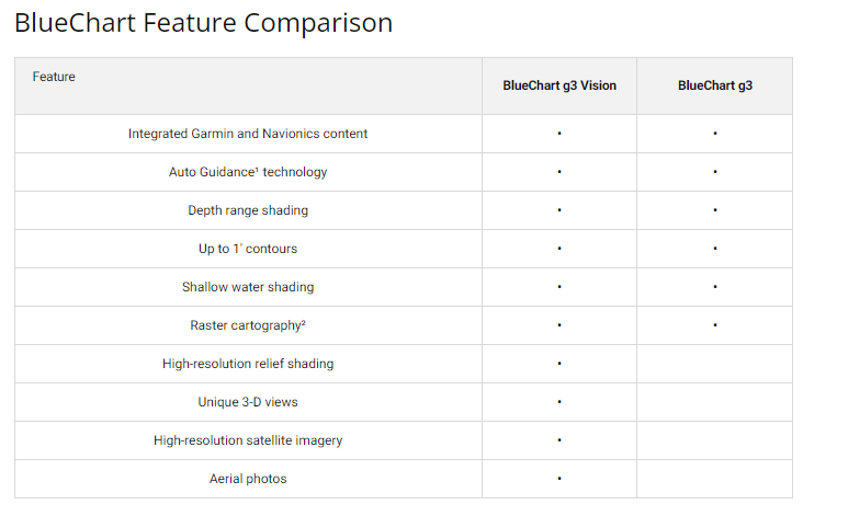
- Integrated Garmin and Navionics® Data: Comprehensive coastal charts with a blend of Garmin and Navionics® information for unparalleled coverage.
- Auto Guidance Technology: Quickly calculates routes based on desired depth and overhead clearance, ensuring safety on the water.
- Depth Range Shading: View shading for up to 10 depth levels, simplifying target depth identification.
- Accurate Contours: Enjoy precise bottom structure representation with 1-foot contours for better fishing and navigation.
- Shallow Water Shading: User-defined shading highlights shallow areas, helping you avoid hazards.
- Enhanced Visual Experience: High-resolution relief shading and FishEye view provide detailed underwater structure representations.
Data Insights
The Garmin BlueChart g3 Vision boasts significant performance metrics, such as offering up to 3 times more detail than previous charting solutions. This comprehensive data ensures that whether you're navigating through Galway Bay or the Shannon Inland Waterway, you can do so with confidence and precision.
Usage Instructions
To achieve optimal performance, simply insert the microSD/SD card into your compatible Garmin device. Utilize the Auto Guidance Technology to set your route, and make full use of the depth shading features to identify safe navigational paths. Regularly update your charts to ensure you have the latest data available.
Design & Material
The Garmin BlueChart g3 Vision is designed with cutting-edge technology and high-quality materials to deliver superior performance. Its user-friendly interface and intuitive features make navigation a breeze.
- High-Resolution Satellite Imagery: Provides realistic visuals for better navigation.
- Aerial Photography: Offers exceptional clarity for ports, harbors, and marinas.
- Durable MicroSD/SD Card: Ensures longevity and reliability in various weather conditions.
- Comprehensive Coverage: Includes areas from Kilkieran to Cork, enhancing exploration options.
- 3-D Visualization: Enhances understanding of underwater features and surrounding areas.
- User-Friendly Interface: Simplifies navigation and route planning.
Final Verdict
The Garmin BlueChart g3 Vision | VEU483S is an essential tool for anyone looking to navigate the stunning waters of Ireland. With its advanced features and comprehensive data, this charting solution not only enhances your on-water experience but also promotes safety and confidence. Don't miss out on this premium navigation tool—order yours today and set sail with ease!


