


Garmin Norway, Vestfjd to Svalbard and Varanger Charts BlueChart g3 | HXEU054R | microSD/SD
Garmin Norway, Vestfjd to Svalbard and Varanger Charts BlueChart g3 | HXEU054R | microSD/SD
Model Number: 010-C0790-20
In stock
 WhatsApp
 SMS - Text us!
 Email Us!
 Help Desk


Tech Specs
In The Box
Garmin Bluechart G2 Vestfjd-Svalbard-Varanger
Do you have an old GPS unit lying around? The GPS Nation Trade In and Up program is a great way to trade in your old and used GPS for credit towards a new GPS. The choice is entirely yours! We’ve made the process simple and streamlined. Follow these simple steps, and you will be on your way to receiving credit towards your brand new GPS!
1. Get a quote
To get your free quote, provide your GPS type, manufacturer, model, and condition. Within 24 hours, you will receive a quote for the trade-in value of your current product. The GPS trade-in/trade-up form is at the bottom of this page.
2. Ship your product(s) for trade
After accepting our offer, pack your product(s) safely and ship them to us using the pre-paid shipping label provided to you. We will provide a confirmation email when your trade-in arrives at our warehouse. You have 30 days from the date you complete your on-line trade to ship the product to GPS Nation.
3. Make your purchase
Once we receive your product at our warehouse and we validate the stated condition, we will send you a confirmation email. If you elect to receive credit towards a new GPS at gpsnation.com, your store credit will be issued, and you are free to make your purchase.
Manual & Warranty
 Garmin Warranty
Reviews
Ask a Question
Tech Specs
In The Box
Garmin Bluechart G2 Vestfjd-Svalbard-Varanger
Trade-In
Do you have an old GPS unit lying around? The GPS Nation Trade In and Up program is a great way to trade in your old and used GPS for credit towards a new GPS. The choice is entirely yours! We’ve made the process simple and streamlined. Follow these simple steps, and you will be on your way to receiving credit towards your brand new GPS!
1. Get a quote
To get your free quote, provide your GPS type, manufacturer, model, and condition. Within 24 hours, you will receive a quote for the trade-in value of your current product. The GPS trade-in/trade-up form is at the bottom of this page.
2. Ship your product(s) for trade
After accepting our offer, pack your product(s) safely and ship them to us using the pre-paid shipping label provided to you. We will provide a confirmation email when your trade-in arrives at our warehouse. You have 30 days from the date you complete your on-line trade to ship the product to GPS Nation.
3. Make your purchase
Once we receive your product at our warehouse and we validate the stated condition, we will send you a confirmation email. If you elect to receive credit towards a new GPS at gpsnation.com, your store credit will be issued, and you are free to make your purchase.
Manual & Warranty
Overview
Garmin BlueChart g3 Norway, Vestfjorden to Svalbard and Varanger Charts (HXEU054R)
Introduction
The Garmin BlueChart g3 HXEU054R chart delivers precise marine navigation and fishing capability across some of Norway's most challenging and rewarding waters, from Vestfjorden's fjord systems through the remote Arctic waters surrounding Svalbard and into the Varanger region. This microSD/SD formatted chart combines official Garmin and Navionics data sources to provide the depth accuracy, detailed contours, and obstacle identification serious anglers and coastal cruisers need when operating in Northern European waters where weather changes rapidly and safe passages narrow considerably.
Key Features
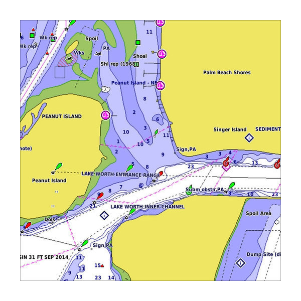
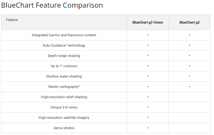
- Depth range shading with support for up to 10 simultaneous depth bands, enabling quick visual assessment of target fishing depths and safe navigation corridors
- 1-foot contour line intervals throughout mapped areas, providing the resolution required for accurate depth profiling in variable seabeds
- Auto Guidance technology that calculates and suggests safe routes to selected destinations while accounting for charted obstacles and minimum depths
- Shallow water shading with user-configurable thresholds, highlighting hazardous areas based on individual vessel draft requirements
- Integrated crowd-sourced data contributing 10% additional coverage beyond official chart sources, covering over 5,000 annual updates
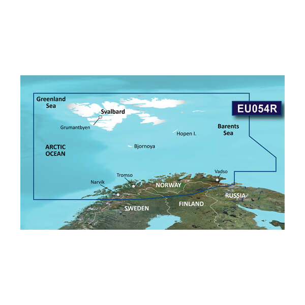
- Complete geographic coverage spanning Vestfjorden, the full Norwegian coast north to Svalbard, and the Varanger Peninsula extending into the Barents Sea region
Data Insights
The BlueChart g3 platform achieves 90% coverage of critical marine areas through official charting data, with an additional 10% derived from crowd-sourced mariner updates, creating a hybrid dataset that reflects both institutional accuracy and real-world navigation experience. The annual update frequency of 5,000-plus modifications ensures that newly discovered hazards, depth changes from sedimentation, and altered navigation markers are regularly incorporated, reducing the time lag between physical changes in Arctic and subarctic waters and chart availability.
Usage Instructions
Insert the microSD/SD card into any compatible Garmin chartplotter, GPS, or marine navigation device to access the full dataset immediately. Activate Auto Guidance to receive turn-by-turn routing suggestions tailored to your vessel's specifications. Layer the depth range shading views alongside contour line displays to cross-reference fishing targets and safe approach depths. Configure shallow water shading alerts according to your specific draft to prevent unexpected groundings in variable-depth fjords and coastal passages.
Design & Material
This chart card employs the microSD/SD format standard to Garmin marine devices, ensuring broad device compatibility without requiring specialized adapters or conversion software. The data structure prioritizes rapid loading times and responsive zoom functions across varying processor speeds found in marine electronics installed across fishing vessels and cruising sailboats operating in remote regions with limited service infrastructure.
- Format: microSD/SD card with direct compatibility to Garmin chartplotters, handhelds, and multifunction displays manufactured within the past decade
- Data integration: Layered architecture combining official Garmin base charts with real-time Navionics corrections and user contributions
- Cartographic detail: Bathymetric contours, underwater hazards, wreck markers, and charted obstructions verified against multiple source documents
- Environmental engineering: Sealed card design rated for temperature extremes from Arctic conditions exceeding negative 20 degrees Celsius to tropical storage environments
- Update delivery: Digital distribution via Garmin BaseCamp software or direct device download, enabling fleet-wide chart synchronization without individual card redistribution
- Navigation interface: User-configurable display modes separating fishing-specific data layers from standard ECDIS-equivalent safety and routing information
Final Verdict
For anyone operating a fishing boat, cruising sailboat, or expedition vessel in Norwegian Arctic waters, the BlueChart g3 HXEU054R eliminates the uncertainty of navigating with outdated or incomplete chart data. The combination of official cartography with verified crowd-sourced updates, coupled with fishing-specific depth visualization tools and Auto Guidance route planning, transforms navigation planning from a time-consuming manual process into an active, data-informed operation. Purchase this chart now to ensure your next passage through Svalbard's surrounding waters, Vestfjorden's complex channel system, or the Varanger coastline is navigated with current, accurate bathymetric information specifically designed for your Garmin device.


