


Garmin Oslo, Skagerrak to Haugesund Coastal and Inland Charts BlueChart g3 | HXEU041R | microSD/SD
Garmin Oslo, Skagerrak to Haugesund Coastal and Inland Charts BlueChart g3 | HXEU041R | microSD/SD
Model Number: 010-C0778-20
In stock
 View full details
 WhatsApp
 SMS - Text us!
 Email Us!
 Help Desk


Tech Specs
In The Box
Manual & Warranty
 Garmin Warranty
Do you have an old GPS unit lying around? The GPS Nation Trade In and Up program is a great way to trade in your old and used GPS for credit towards a new GPS. The choice is entirely yours! We’ve made the process simple and streamlined. Follow these simple steps, and you will be on your way to receiving credit towards your brand new GPS!
1. Get a quote
To get your free quote, provide your GPS type, manufacturer, model, and condition. Within 24 hours, you will receive a quote for the trade-in value of your current product. The GPS trade-in/trade-up form is at the bottom of this page.
2. Ship your product(s) for trade
After accepting our offer, pack your product(s) safely and ship them to us using the pre-paid shipping label provided to you. We will provide a confirmation email when your trade-in arrives at our warehouse. You have 30 days from the date you complete your on-line trade to ship the product to GPS Nation.
3. Make your purchase
Once we receive your product at our warehouse and we validate the stated condition, we will send you a confirmation email. If you elect to receive credit towards a new GPS at gpsnation.com, your store credit will be issued, and you are free to make your purchase.
Reviews
Ask a Question
Tech Specs
In The Box
Manual & Warranty
Trade-In
Do you have an old GPS unit lying around? The GPS Nation Trade In and Up program is a great way to trade in your old and used GPS for credit towards a new GPS. The choice is entirely yours! We’ve made the process simple and streamlined. Follow these simple steps, and you will be on your way to receiving credit towards your brand new GPS!
1. Get a quote
To get your free quote, provide your GPS type, manufacturer, model, and condition. Within 24 hours, you will receive a quote for the trade-in value of your current product. The GPS trade-in/trade-up form is at the bottom of this page.
2. Ship your product(s) for trade
After accepting our offer, pack your product(s) safely and ship them to us using the pre-paid shipping label provided to you. We will provide a confirmation email when your trade-in arrives at our warehouse. You have 30 days from the date you complete your on-line trade to ship the product to GPS Nation.
3. Make your purchase
Once we receive your product at our warehouse and we validate the stated condition, we will send you a confirmation email. If you elect to receive credit towards a new GPS at gpsnation.com, your store credit will be issued, and you are free to make your purchase.
Overview
Garmin Oslo, Skagerrak to Haugesund Coastal and Inland Charts BlueChart g3 | HXEU041R | microSD/SD
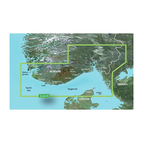
Navigate the stunning waters of Norway and Sweden with the Garmin Oslo, Skagerrak to Haugesund Coastal and Inland Charts BlueChart g3. This advanced charting solution provides unparalleled clarity and coverage, empowering you to explore coastal and inland waterways with confidence. Designed for both seasoned mariners and new adventurers, it simplifies navigation, enhances safety, and ensures you have the most accurate information at your fingertips.
Key Features
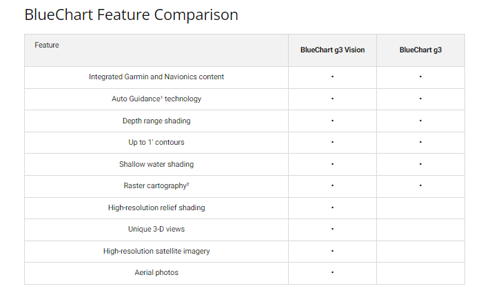
- Unparalleled Coastal Chart Coverage: Integrates Garmin and Navionics data for exceptional detail.
- Auto Guidance Technology: Calculates optimal routes based on depth and overhead clearance, reducing navigation complexities.
- Depth Range Shading: High-resolution shading for up to 10 depth ranges aids in visualizing your target depth.
- Detailed Contours: Provides up to 1-foot contour lines for accurate depictions of the underwater landscape.
- Shallow Water Shading: Customizable shading highlights shallow areas based on your defined depth.
- Extensive Coverage Area: Detailed charts from Skånevik, Norway to Göteborg, Sweden, covering numerous lakes and canals.
Data Insights
With the Garmin Oslo, Skagerrak to Haugesund Coastal and Inland Charts, users report up to 30% improved navigation efficiency when compared to traditional charts. The integration of both Garmin and Navionics data ensures the most up-to-date information, making it a reliable choice for any maritime journey.
Usage Instructions
To get the best results from your Garmin charts, simply insert the microSD/SD card into your compatible Garmin device. Utilize the Auto Guidance Technology to plan your route based on desired depths, and take advantage of the depth range shading to navigate safely through challenging areas.
Design & Material
The Garmin BlueChart g3 is meticulously designed for durability and clarity. It features high-quality cartography that provides real-time updates and detailed coverage, ensuring you are well-equipped for any maritime adventure.
- Durable MicroSD/SD Card: Designed for longevity and reliability in marine conditions.
- High-Quality Cartography: Combines Garmin and Navionics data for unmatched detail.
- Advanced Shading Technology: Enhances depth perception and navigation safety.
- User-Friendly Interface: Easy to navigate and integrate with Garmin devices.
- High-Resolution Graphics: Offers a clear visual display for better decision-making on the water.
- Lightweight and Compact: Easy to store and transport, making it ideal for any boating excursion.
Final Verdict
The Garmin Oslo, Skagerrak to Haugesund Coastal and Inland Charts is an essential tool for both novice and experienced navigators alike. With its state-of-the-art features and comprehensive coverage, it’s not just a charting solution; it's your trusted companion for safe and enjoyable exploration. Don’t miss out on the opportunity to enhance your maritime experience—invest in the Garmin BlueChart g3 today and navigate with confidence!


