


Garmin South America, West Coast Charts BlueChart g3 | HXSA002R | microSD/SD
Garmin South America, West Coast Charts BlueChart g3 | HXSA002R | microSD/SD
Model Number: 010-C1063-20
In stock
 WhatsApp
 SMS - Text us!
 Email Us!
 Help Desk

Tech Specs
In The Box
Do you have an old GPS unit lying around? The GPS Nation Trade In and Up program is a great way to trade in your old and used GPS for credit towards a new GPS. The choice is entirely yours! We’ve made the process simple and streamlined. Follow these simple steps, and you will be on your way to receiving credit towards your brand new GPS!
1. Get a quote
To get your free quote, provide your GPS type, manufacturer, model, and condition. Within 24 hours, you will receive a quote for the trade-in value of your current product. The GPS trade-in/trade-up form is at the bottom of this page.
2. Ship your product(s) for trade
After accepting our offer, pack your product(s) safely and ship them to us using the pre-paid shipping label provided to you. We will provide a confirmation email when your trade-in arrives at our warehouse. You have 30 days from the date you complete your on-line trade to ship the product to GPS Nation.
3. Make your purchase
Once we receive your product at our warehouse and we validate the stated condition, we will send you a confirmation email. If you elect to receive credit towards a new GPS at gpsnation.com, your store credit will be issued, and you are free to make your purchase.
Manual & Warranty
 Garmin Warranty
Reviews
Ask a Question
Tech Specs
In The Box
Trade-In
Do you have an old GPS unit lying around? The GPS Nation Trade In and Up program is a great way to trade in your old and used GPS for credit towards a new GPS. The choice is entirely yours! We’ve made the process simple and streamlined. Follow these simple steps, and you will be on your way to receiving credit towards your brand new GPS!
1. Get a quote
To get your free quote, provide your GPS type, manufacturer, model, and condition. Within 24 hours, you will receive a quote for the trade-in value of your current product. The GPS trade-in/trade-up form is at the bottom of this page.
2. Ship your product(s) for trade
After accepting our offer, pack your product(s) safely and ship them to us using the pre-paid shipping label provided to you. We will provide a confirmation email when your trade-in arrives at our warehouse. You have 30 days from the date you complete your on-line trade to ship the product to GPS Nation.
3. Make your purchase
Once we receive your product at our warehouse and we validate the stated condition, we will send you a confirmation email. If you elect to receive credit towards a new GPS at gpsnation.com, your store credit will be issued, and you are free to make your purchase.
Manual & Warranty
Overview
Garmin South America, West Coast Charts BlueChart g3 (HXSA002R) — Detailed Marine Navigation for Pacific and Caribbean Waters
Introduction
The Garmin South America, West Coast Charts BlueChart g3 delivers precise, high-resolution marine navigation data across one of the world's most geographically complex coastal regions. This microSD/SD card-based chart package provides mariners and fishing enthusiasts with detailed bathymetric data, real-time depth awareness, and advanced 3D visualization tools that transform raw navigation data into actionable intelligence for safer passage through South American and Central American waters.
Key Features
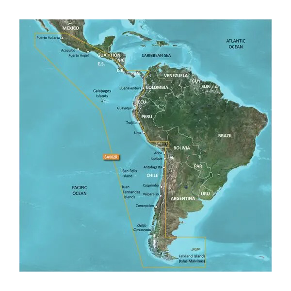
- Geographic coverage spanning Acapulco, Mexico, southward to Tierra del Fuego, Argentina, including Panama's eastern coast and the Galapagos Islands
- 97% coverage of targeted regional waters, delivering comprehensive chart availability across specified navigation zones
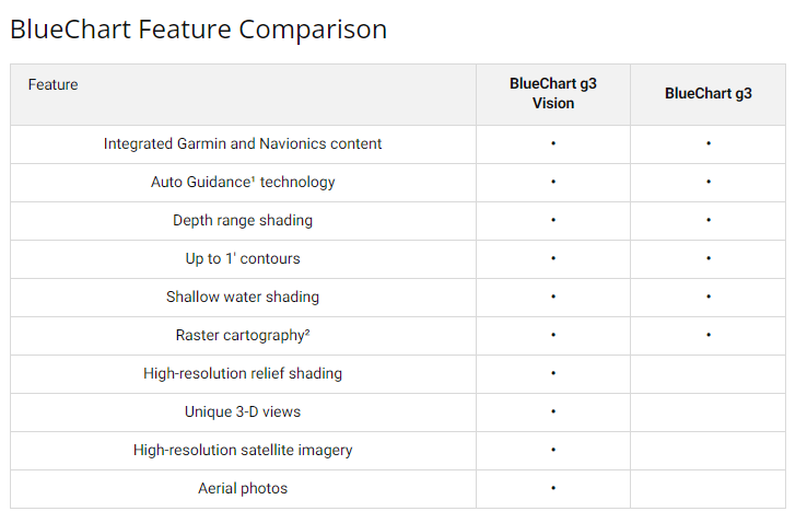
- 10 distinct depth range shading levels for rapid visual identification of bottom contours and target fishing depths
- Up to 1-foot contour intervals providing granular seafloor structure detail for precision anchoring and shallow-water navigation
- Auto Guidance Technology calculating optimal routes based on vessel dimensions and hull specifications
- Dual 3D visualization modes—MarinerEye and FishEye—rendering underwater terrain from navigational and fishing perspectives
- High-resolution satellite imagery overlay capability enabling chart comparison against real-time visual reference
- Aerial photography of major ports, harbors, and marinas for pre-arrival familiarization
Data Insights
This chart compilation integrates data from official hydrographic surveys and supplementary private cartographic sources, resulting in accuracy suitable for both commercial transit and recreational navigation. The 97% coverage metric reflects extensive data collection across Central America's Caribbean passages, the Pacific coast's deep-water corridors, and complex inland waterways. Mariners using depth range shading and 1-foot contours report substantially reduced grounding risk and improved anchor site selection, particularly in regions with dramatic tidal ranges and irregular bottom composition.
Usage Instructions
Insert the microSD/SD card into any compatible Garmin chartplotter, echosounder, or handheld marine GPS device. The plug-and-play format eliminates complex installation steps; your device will recognize and activate the charts immediately. Ensure your Garmin device runs current firmware to access all chart features and periodic data updates released by Garmin's hydrographic team. For optimal performance, verify your vessel's dimensions are entered in the Auto Guidance settings.
Design & Material
The BlueChart g3 card is engineered specifically for marine use, combining durable microSD/SD memory storage with high-resolution graphics rendering optimized for sunlit screen environments. The compact form factor ensures compatibility across Garmin's full marine device ecosystem without requiring adapters or proprietary cartridges.
- Rugged microSD/SD card construction rated for salt-spray and humidity exposure typical of marine environments
- Instant compatibility across Garmin chartplotters, GPSMAP handhelds, and integrated marine systems without external adapters
- Crisp vector and raster graphics rendering clearly on high-brightness marine displays and standard computer monitors
- Lightweight, pocket-sized form enabling backup chart storage or rapid device upgrades
- Automatic data structure recognition—no manual configuration or chart file conversion required
- Ongoing chart update releases through Garmin's BlueChart subscription service, ensuring alignment with latest surveys and corrections
Final Verdict
Mariners navigating South American and Central American waters demand charts that translate geological complexity into actionable route planning and hazard avoidance. The Garmin BlueChart g3 West Coast package delivers comprehensive coverage, granular depth data, and predictive navigation technology in a format compatible with virtually all modern Garmin marine devices. If you operate regularly between Mexico and Argentina, or fish the region's productive offshore and nearshore grounds, this chart set eliminates navigation guesswork. Order today and gain confidence in waters where accurate bathymetric data and precise route calculation directly impact safety and success.


