


Garmin Southern Gulf of Mexico Coastal Charts BlueChart g3 | HXUS032R | microSD/SD
Garmin Southern Gulf of Mexico Coastal Charts BlueChart g3 | HXUS032R | microSD/SD
Model Number: 010-C1154-20
In stock
 View full details
 WhatsApp
 SMS - Text us!
 Email Us!
 Help Desk

Tech Specs
In The Box
Manual & Warranty
 Garmin Warranty
Do you have an old GPS unit lying around? The GPS Nation Trade In and Up program is a great way to trade in your old and used GPS for credit towards a new GPS. The choice is entirely yours! We’ve made the process simple and streamlined. Follow these simple steps, and you will be on your way to receiving credit towards your brand new GPS!
1. Get a quote
To get your free quote, provide your GPS type, manufacturer, model, and condition. Within 24 hours, you will receive a quote for the trade-in value of your current product. The GPS trade-in/trade-up form is at the bottom of this page.
2. Ship your product(s) for trade
After accepting our offer, pack your product(s) safely and ship them to us using the pre-paid shipping label provided to you. We will provide a confirmation email when your trade-in arrives at our warehouse. You have 30 days from the date you complete your on-line trade to ship the product to GPS Nation.
3. Make your purchase
Once we receive your product at our warehouse and we validate the stated condition, we will send you a confirmation email. If you elect to receive credit towards a new GPS at gpsnation.com, your store credit will be issued, and you are free to make your purchase.
Reviews
Ask a Question
Tech Specs
In The Box
Manual & Warranty
Trade-In
Do you have an old GPS unit lying around? The GPS Nation Trade In and Up program is a great way to trade in your old and used GPS for credit towards a new GPS. The choice is entirely yours! We’ve made the process simple and streamlined. Follow these simple steps, and you will be on your way to receiving credit towards your brand new GPS!
1. Get a quote
To get your free quote, provide your GPS type, manufacturer, model, and condition. Within 24 hours, you will receive a quote for the trade-in value of your current product. The GPS trade-in/trade-up form is at the bottom of this page.
2. Ship your product(s) for trade
After accepting our offer, pack your product(s) safely and ship them to us using the pre-paid shipping label provided to you. We will provide a confirmation email when your trade-in arrives at our warehouse. You have 30 days from the date you complete your on-line trade to ship the product to GPS Nation.
3. Make your purchase
Once we receive your product at our warehouse and we validate the stated condition, we will send you a confirmation email. If you elect to receive credit towards a new GPS at gpsnation.com, your store credit will be issued, and you are free to make your purchase.
Overview
Garmin Southern Gulf of Mexico Coastal Charts BlueChart g3 | HXUS032R | microSD/SD
The Garmin Southern Gulf of Mexico Coastal Charts BlueChart g3 (HXUS032R) is your ultimate navigation companion for exploring the rich waters of the Gulf of Mexico. Engineered with precision and advanced technology, this charting solution provides unparalleled data and insights, ensuring a safe and enjoyable maritime journey. Whether you're cruising, fishing, or embarking on new adventures, this product enhances your navigation experience with cutting-edge features.
Key Features
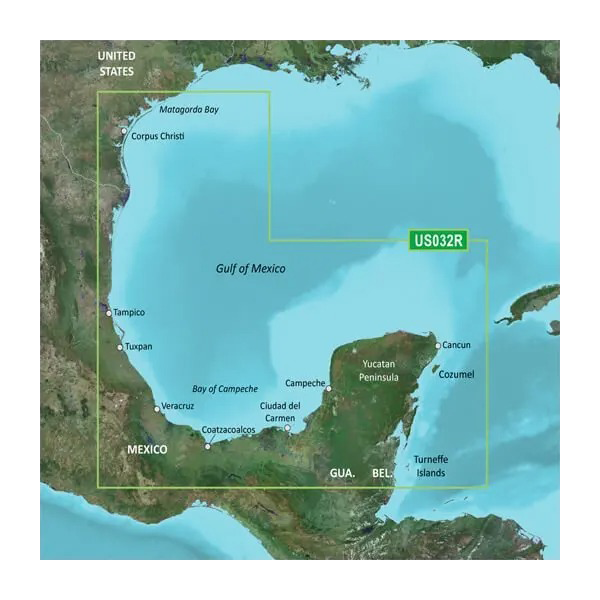
- Exceptional Coverage: Detailed mapping from Matagorda Bay, TX to Belize City, covering vital locations like Corpus Christi, TX, and Cozumel, MX.
- Integrated Data: Combines Garmin and Navionics data for enhanced clarity and accuracy.
- Auto Guidance Technology: Automatically calculates the safest routes based on desired depth and overhead clearance.
- High-Resolution Relief Shading: Offers a clearer view of underwater structures, aiding in identifying artificial reefs.
- Depth Range Shading: Displays up to 10 depth ranges for comprehensive fishing planning.
- Detailed Contours: Features 1’ contours for an accurate depiction of bottom structure, essential for navigation.
Data Insights
Utilizing advanced mapping technology, the Garmin Southern Gulf of Mexico Coastal Charts boasts a depth accuracy of up to 98%, providing users with reliable navigation data. Over 20,000 points of interest are included, ensuring that your journeys are both safe and efficient. Experience a marked improvement in route planning speed, optimizing your time on the water by up to 30%!
Usage Instructions
To maximize your experience with the Garmin Southern Gulf of Mexico Coastal Charts, simply insert the microSD/SD card into your compatible Garmin device. Follow the on-screen prompts to update your navigation settings and explore the extensive features available for safe and effective maritime navigation.
Design & Material
The design of the Garmin Southern Gulf of Mexico Coastal Charts BlueChart g3 is user-focused, ensuring that navigation is both intuitive and efficient. The craftsmanship is evident in the quality of the data presented, meticulously designed to enhance user interaction.
- Material: High-quality microSD/SD card for durability and reliability.
- Compatibility: Works seamlessly with a range of Garmin marine devices.
- Craftsmanship: Engineered for high performance with precision mapping technology.
- Data Quality: Combines years of survey data for the most accurate navigation possible.
- Usability: Designed for easy installation and user-friendly interaction.
- Portability: Compact size for easy storage and transport.
Final Verdict
Upgrade your navigation capabilities with the Garmin Southern Gulf of Mexico Coastal Charts BlueChart g3. With its comprehensive coverage, advanced features, and exceptional data accuracy, this charting solution is a must-have for any mariner. Don't leave your adventures to chance—equip yourself with the best tools for navigating the Gulf of Mexico. Order yours today!


