


Garmin Southern Gulf of Mexico Coastal Charts BlueChart g3 Vision | VUS032R | microSD/SD
Garmin Southern Gulf of Mexico Coastal Charts BlueChart g3 Vision | VUS032R | microSD/SD
Model Number: 010-C0733-00
In stock
 WhatsApp
 SMS - Text us!
 Email Us!
 Help Desk

Tech Specs
In The Box
Do you have an old GPS unit lying around? The GPS Nation Trade In and Up program is a great way to trade in your old and used GPS for credit towards a new GPS. The choice is entirely yours! We’ve made the process simple and streamlined. Follow these simple steps, and you will be on your way to receiving credit towards your brand new GPS!
1. Get a quote
To get your free quote, provide your GPS type, manufacturer, model, and condition. Within 24 hours, you will receive a quote for the trade-in value of your current product. The GPS trade-in/trade-up form is at the bottom of this page.
2. Ship your product(s) for trade
After accepting our offer, pack your product(s) safely and ship them to us using the pre-paid shipping label provided to you. We will provide a confirmation email when your trade-in arrives at our warehouse. You have 30 days from the date you complete your on-line trade to ship the product to GPS Nation.
3. Make your purchase
Once we receive your product at our warehouse and we validate the stated condition, we will send you a confirmation email. If you elect to receive credit towards a new GPS at gpsnation.com, your store credit will be issued, and you are free to make your purchase.
Manual & Warranty
 Garmin Warranty
Reviews
Ask a Question
Tech Specs
In The Box
Trade-In
Do you have an old GPS unit lying around? The GPS Nation Trade In and Up program is a great way to trade in your old and used GPS for credit towards a new GPS. The choice is entirely yours! We’ve made the process simple and streamlined. Follow these simple steps, and you will be on your way to receiving credit towards your brand new GPS!
1. Get a quote
To get your free quote, provide your GPS type, manufacturer, model, and condition. Within 24 hours, you will receive a quote for the trade-in value of your current product. The GPS trade-in/trade-up form is at the bottom of this page.
2. Ship your product(s) for trade
After accepting our offer, pack your product(s) safely and ship them to us using the pre-paid shipping label provided to you. We will provide a confirmation email when your trade-in arrives at our warehouse. You have 30 days from the date you complete your on-line trade to ship the product to GPS Nation.
3. Make your purchase
Once we receive your product at our warehouse and we validate the stated condition, we will send you a confirmation email. If you elect to receive credit towards a new GPS at gpsnation.com, your store credit will be issued, and you are free to make your purchase.
Manual & Warranty
Overview
Garmin Southern Gulf of Mexico Coastal Charts BlueChart g3 Vision VUS032R
Introduction
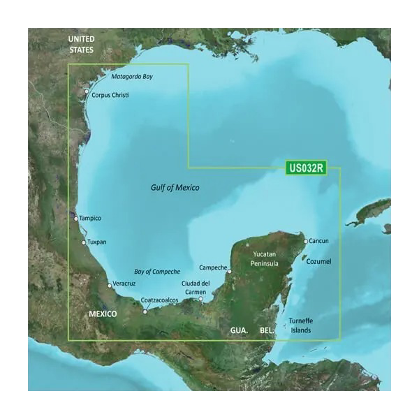
The Garmin VUS032R BlueChart g3 Vision chart card delivers high-resolution coastal navigation data specifically optimized for the Southern Gulf of Mexico, from Corpus Christi and Matagorda Bay along the Texas coast through the Yucatan Peninsula and into the Caribbean. This microSD/SD card integrates Garmin and Navionics datasets to provide fishermen, cruisers, and boaters with the detailed bathymetric and coastal information needed to navigate confidently in these waters. Whether you're targeting offshore structure, transiting to Cancun, or exploring the Turneffe Islands, this charting solution combines modern satellite imagery with traditional paper chart accuracy.
Key Features
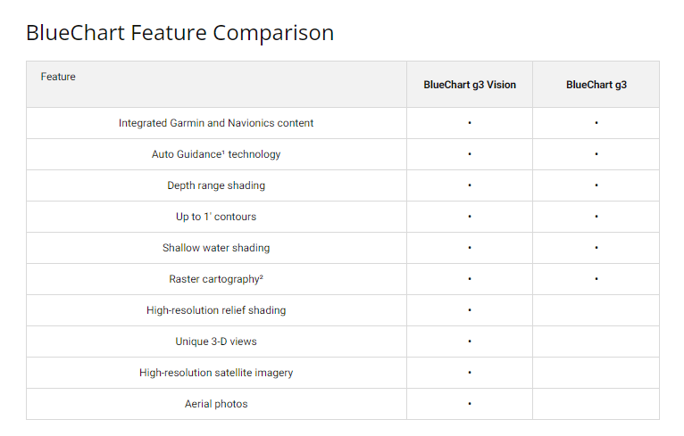
- Depth range shading displays up to 10 distinct color-coded depth zones for rapid visual identification of shallow and deep water
- Ultra-fine 1-foot contour line intervals reveal underwater structure with precision unavailable on standard regional charts
- Auto Guidance technology calculates safe transit routes by analyzing real-time depth data and overhead clearances
- NOAA raster cartography integration provides 100% coverage of surveyed U.S. coastal zones with official government chart accuracy
- High-resolution relief shading covers the entire continental U.S. coast plus extended Mexican and Caribbean waters
- Shallow water customization allows user-defined depth alerts starting at 3 feet, 6 feet, 10 feet, or deeper thresholds
Data Insights
This chart card leverages combined Navionics and Garmin data sources to deliver comprehensive coverage of the Southern Gulf of Mexico. The integration of satellite imagery and NOAA survey data ensures that navigation hazards, underwater terrain changes, and coastal features are represented with the accuracy demanded by commercial and recreational boaters. Users gain access to free downloadable NOAA raster chart files for offline reference in surveyed areas, effectively providing dual-layer navigation redundancy.
Usage Instructions
Insert the microSD/SD card into any compatible Garmin chartplotter, such as the ECHOMAP, GPSMAP, or similar series units. Once recognized by your device, activate Auto Guidance to receive turn-by-turn route recommendations that respect water depth and vertical clearance for your vessel. Customize depth range shading to match local conditions—shallow Gulf waters demand different thresholds than deep-water approaches. Enable depth alerts to maintain safe clearance as you navigate reefs, flats, and shipping channels.
Design & Material
The VUS032R is engineered as a rugged, weather-sealed data card designed to function reliably in the humid marine environment of the Gulf of Mexico and Caribbean. The compact form factor integrates seamlessly into existing Garmin hardware without requiring installation changes or additional equipment.
- Durable microSD/SD card construction rated for saltwater and UV exposure common in marine use
- Compact 32 x 24 mm form factor fits all standard Garmin card slots without adapters
- Weather-resistant housing protects stored data from moisture infiltration and corrosion
- Lightweight design eliminates any measurable weight addition to your navigation system
- Compatible with Garmin BlueChart g3 Vision platform, ensuring seamless integration with existing cartography
- Proven Garmin-Navionics combined data source delivers the reliability demanded by professional fishing and charter operations
Final Verdict
The Garmin VUS032R is essential for anyone operating in the Southern Gulf of Mexico. With 1-foot contour precision, 10-depth range shading, and Auto Guidance technology, this chart card eliminates guesswork and delivers the navigation confidence required for safe passage through complex coastal waters. Whether you fish the reefs off Turneffe Islands, cruise the shallow bays near Corpus Christi, or navigate toward Cozumel, this card provides the accuracy and detail that separate confident navigation from risky guessing. Upgrade your Garmin system with the VUS032R and chart your course with certainty.


