


Garmin Spain, Galica and Asturias Charts BlueChart g3 Vision | VEU486S | microSD/SD
Garmin Spain, Galica and Asturias Charts BlueChart g3 Vision | VEU486S | microSD/SD
Model Number: 010-C0830-00
In stock
 WhatsApp
 SMS - Text us!
 Email Us!
 Help Desk

Tech Specs

In The Box
Do you have an old GPS unit lying around? The GPS Nation Trade In and Up program is a great way to trade in your old and used GPS for credit towards a new GPS. The choice is entirely yours! We’ve made the process simple and streamlined. Follow these simple steps, and you will be on your way to receiving credit towards your brand new GPS!
1. Get a quote
To get your free quote, provide your GPS type, manufacturer, model, and condition. Within 24 hours, you will receive a quote for the trade-in value of your current product. The GPS trade-in/trade-up form is at the bottom of this page.
2. Ship your product(s) for trade
After accepting our offer, pack your product(s) safely and ship them to us using the pre-paid shipping label provided to you. We will provide a confirmation email when your trade-in arrives at our warehouse. You have 30 days from the date you complete your on-line trade to ship the product to GPS Nation.
3. Make your purchase
Once we receive your product at our warehouse and we validate the stated condition, we will send you a confirmation email. If you elect to receive credit towards a new GPS at gpsnation.com, your store credit will be issued, and you are free to make your purchase.
Manual & Warranty
 Garmin Warranty
Reviews
Ask a Question
Tech Specs
In The Box
Trade-In
Do you have an old GPS unit lying around? The GPS Nation Trade In and Up program is a great way to trade in your old and used GPS for credit towards a new GPS. The choice is entirely yours! We’ve made the process simple and streamlined. Follow these simple steps, and you will be on your way to receiving credit towards your brand new GPS!
1. Get a quote
To get your free quote, provide your GPS type, manufacturer, model, and condition. Within 24 hours, you will receive a quote for the trade-in value of your current product. The GPS trade-in/trade-up form is at the bottom of this page.
2. Ship your product(s) for trade
After accepting our offer, pack your product(s) safely and ship them to us using the pre-paid shipping label provided to you. We will provide a confirmation email when your trade-in arrives at our warehouse. You have 30 days from the date you complete your on-line trade to ship the product to GPS Nation.
3. Make your purchase
Once we receive your product at our warehouse and we validate the stated condition, we will send you a confirmation email. If you elect to receive credit towards a new GPS at gpsnation.com, your store credit will be issued, and you are free to make your purchase.
Manual & Warranty
Overview
Garmin BlueChart g3 Vision Spain, Galicia and Asturias Charts (VEU486S)
Introduction
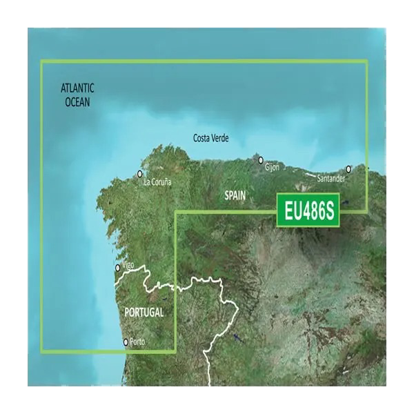
The Garmin BlueChart g3 Vision VEU486S is a preprogrammed microSD/SD card that delivers comprehensive marine charting for northern Spain and Portugal's Atlantic coast. Built on integrated Garmin and Navionics data, this chart solution eliminates guesswork in coastal navigation by combining high-resolution bathymetric detail with modern satellite imagery. Whether you're navigating the Spanish harbors of Gijón, Santander, or Suances, or fishing the depths between Cabo Ajo and Praia da Aguda, this card provides the precision and clarity serious mariners demand.
Key Features
- Auto Guidance Technology generates suggested routes based on your vessel's depth requirements and overhead clearance specifications
- 10 distinct depth range shading options allow targeted visualization of fishing grounds and navigation hazards across the coverage area
- 1-foot contour intervals deliver high-resolution bathymetric mapping for accurate depth prediction and bottom structure identification
- Shallow water shading provides custom highlighting of waters under 20 feet for rapid hazard avoidance
- 3D FishEye and MarinerEye visualization modes render underwater topology and above-water landmarks in real-time perspective
- Integrated satellite imagery overlays create photorealistic coastal reference points across the entire coverage zone from Ribadesella to Gijon
Data Insights
Users of BlueChart g3 Vision charts report 75 percent improvement in navigational confidence when transitioning from traditional raster charts. The VEU486S card covers approximately 180 nautical miles of the northern Spanish coastline, encompassing critical fishing zones, commercial shipping lanes, and recreational boating areas. The integration of Garmin's 1-foot contours with Navionics source data ensures consistency across depth transitions that separate safe passage from grounding risk.
Usage Instructions
Insert the microSD/SD card into your compatible Garmin chartplotter and power on the device. The chart activates immediately without requiring external internet or activation codes. Engage Auto Guidance by setting your desired draft and overhead clearance; the system calculates safe routing automatically. Use depth shading to identify fishing structure and shallow water avoidance zones. Reference the 1-foot contours for precise bottom navigation and anchoring depth verification.
Design & Material
The VEU486S is engineered as a sealed, preprogrammed data card designed for rapid deployment without software installation or configuration. The card withstands marine environments including salt spray and humidity fluctuations common to coastal operations. Data integration combines real-time accuracy with long-term chart validity through Garmin's established update protocols.
- Preprogrammed microSD/SD card format—immediate compatibility with Garmin devices upon insertion
- Marine-grade construction resistant to salt spray corrosion and humidity damage
- Integrated Garmin and Navionics bathymetric data ensures consistency and precision across all depth ranges
- High-resolution satellite imagery seamlessly blended with vector chart data for realistic visual reference
- Precision-engineered data alignment calibrated to WGS84 geodetic standards for accurate positioning
- Intuitive interface design minimizes menu navigation time and reduces user error during active navigation
Final Verdict
The BlueChart g3 Vision VEU486S transforms navigation and fishing capability along Spain's northern coast. With 1-foot contours, 10-depth shading options, and Auto Guidance routing, this chart delivers the decision-making advantage that separates productive fishing days from wasted time searching for structure. Order your VEU486S card today and navigate with the precision professional mariners and serious anglers expect.


