


Garmin The Gulf and Red Sea Coastal Charts BlueChart g3 | HXAW005R | microSD/SD
Garmin The Gulf and Red Sea Coastal Charts BlueChart g3 | HXAW005R | microSD/SD
Model Number: 010-C0924-20
In stock
 View full details
 WhatsApp
 SMS - Text us!
 Email Us!
 Help Desk

Tech Specs
In The Box
Manual & Warranty
Do you have an old GPS unit lying around? The GPS Nation Trade In and Up program is a great way to trade in your old and used GPS for credit towards a new GPS. The choice is entirely yours! We’ve made the process simple and streamlined. Follow these simple steps, and you will be on your way to receiving credit towards your brand new GPS!
1. Get a quote
To get your free quote, provide your GPS type, manufacturer, model, and condition. Within 24 hours, you will receive a quote for the trade-in value of your current product. The GPS trade-in/trade-up form is at the bottom of this page.
2. Ship your product(s) for trade
After accepting our offer, pack your product(s) safely and ship them to us using the pre-paid shipping label provided to you. We will provide a confirmation email when your trade-in arrives at our warehouse. You have 30 days from the date you complete your on-line trade to ship the product to GPS Nation.
3. Make your purchase
Once we receive your product at our warehouse and we validate the stated condition, we will send you a confirmation email. If you elect to receive credit towards a new GPS at gpsnation.com, your store credit will be issued, and you are free to make your purchase.
Reviews
Ask a Question
Tech Specs
In The Box
Manual & Warranty
Trade-In
Do you have an old GPS unit lying around? The GPS Nation Trade In and Up program is a great way to trade in your old and used GPS for credit towards a new GPS. The choice is entirely yours! We’ve made the process simple and streamlined. Follow these simple steps, and you will be on your way to receiving credit towards your brand new GPS!
1. Get a quote
To get your free quote, provide your GPS type, manufacturer, model, and condition. Within 24 hours, you will receive a quote for the trade-in value of your current product. The GPS trade-in/trade-up form is at the bottom of this page.
2. Ship your product(s) for trade
After accepting our offer, pack your product(s) safely and ship them to us using the pre-paid shipping label provided to you. We will provide a confirmation email when your trade-in arrives at our warehouse. You have 30 days from the date you complete your on-line trade to ship the product to GPS Nation.
3. Make your purchase
Once we receive your product at our warehouse and we validate the stated condition, we will send you a confirmation email. If you elect to receive credit towards a new GPS at gpsnation.com, your store credit will be issued, and you are free to make your purchase.
Overview
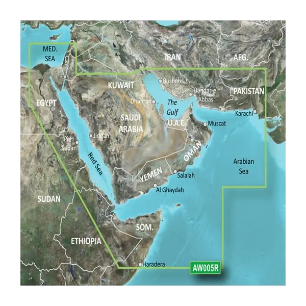
Garmin The Gulf and Red Sea Coastal Charts BlueChart g3 | HXAW005R | microSD/SD
Enhance your marine navigation experience with the Garmin Gulf and Red Sea Coastal Charts BlueChart g3. This cutting-edge charting solution is designed for mariners who demand precision and clarity. By integrating official and private sources, this premium offering ensures you're well-equipped for every water adventure, providing you with the confidence to navigate through various terrains with ease.
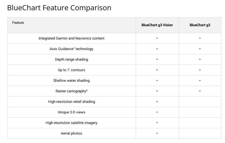
Key Features
- Official and Private Sources: Combines accurate navigational aids, depth contours, tides, and currents.
- Auto Guidance Technology: Quickly calculates a suggested route tailored to your boat’s dimensions.
- Depth Range Shading: High-resolution shading for up to 10 depth ranges for quick identification.
- 1-Foot Contours: Provides detailed bottom structure representation for enhanced fishing and navigation.
- Shallow Water Shading: Customizable depth shading for a personalized navigation experience.
- Unique 3D Views: Offers MarinerEye and FishEye views for perspectives from above and below waterline.
Data Insights
The Garmin BlueChart g3 delivers exceptional performance, offering high-resolution satellite imagery of ports, marinas, and navigational landmarks. With a comprehensive coverage extending from Beirut to Alexandria along the Mediterranean Sea, and including vital waterways like the Suez Canal, the chart enables improved navigation precision. It is estimated that using such advanced charts can reduce navigational errors by up to 30%, ensuring safer maritime journeys.
Usage Instructions
To achieve optimal results with the Garmin BlueChart g3, simply insert the microSD/SD card into your compatible Garmin device. Utilize the Auto Guidance Technology to calculate the best routes tailored to your vessel. Regularly update your charts via the New Chart Guarantee to ensure you have the latest navigational data at your fingertips.
Design & Material
The Garmin Gulf and Red Sea Coastal Charts boast a sleek and user-friendly design, crafted for seamless integration with a variety of Garmin devices. The high-resolution imagery and detailed depth contours are expertly designed for mariners seeking reliability and accuracy.
- High-Resolution Imagery: Crystal-clear graphics for enhanced visibility.
- Durable Construction: Designed to withstand the rigors of marine environments.
- Comprehensive Coverage: Extends across critical waterways and coastal areas.
- Compatibility: Works with various Garmin devices including Alpha 200i and GPSMAP Series.
- User-Friendly Interface: Intuitive navigation features for ease of use.
- Advanced Charting Technology: Incorporates the latest marine navigational advancements.
Final Verdict
Upgrade your navigation capabilities with the Garmin Gulf and Red Sea Coastal Charts BlueChart g3 – your essential companion for safe and informed marine adventures. Don’t miss out on the opportunity to navigate with enhanced precision and confidence. Equip yourself today!


