


Garmin The Gulf and Red Sea Coastal Charts BlueChart g3 Vision | VAW005R | microSD/SD
Garmin The Gulf and Red Sea Coastal Charts BlueChart g3 Vision | VAW005R | microSD/SD
Model Number: 010-C0924-00
Out of stock
 WhatsApp
 SMS - Text us!
 Email Us!
 Help Desk

Tech Specs
In The Box
Do you have an old GPS unit lying around? The GPS Nation Trade In and Up program is a great way to trade in your old and used GPS for credit towards a new GPS. The choice is entirely yours! We’ve made the process simple and streamlined. Follow these simple steps, and you will be on your way to receiving credit towards your brand new GPS!
1. Get a quote
To get your free quote, provide your GPS type, manufacturer, model, and condition. Within 24 hours, you will receive a quote for the trade-in value of your current product. The GPS trade-in/trade-up form is at the bottom of this page.
2. Ship your product(s) for trade
After accepting our offer, pack your product(s) safely and ship them to us using the pre-paid shipping label provided to you. We will provide a confirmation email when your trade-in arrives at our warehouse. You have 30 days from the date you complete your on-line trade to ship the product to GPS Nation.
3. Make your purchase
Once we receive your product at our warehouse and we validate the stated condition, we will send you a confirmation email. If you elect to receive credit towards a new GPS at gpsnation.com, your store credit will be issued, and you are free to make your purchase.
Manual & Warranty
 Garmin Warranty
Reviews
Ask a Question
Tech Specs
In The Box
Trade-In
Do you have an old GPS unit lying around? The GPS Nation Trade In and Up program is a great way to trade in your old and used GPS for credit towards a new GPS. The choice is entirely yours! We’ve made the process simple and streamlined. Follow these simple steps, and you will be on your way to receiving credit towards your brand new GPS!
1. Get a quote
To get your free quote, provide your GPS type, manufacturer, model, and condition. Within 24 hours, you will receive a quote for the trade-in value of your current product. The GPS trade-in/trade-up form is at the bottom of this page.
2. Ship your product(s) for trade
After accepting our offer, pack your product(s) safely and ship them to us using the pre-paid shipping label provided to you. We will provide a confirmation email when your trade-in arrives at our warehouse. You have 30 days from the date you complete your on-line trade to ship the product to GPS Nation.
3. Make your purchase
Once we receive your product at our warehouse and we validate the stated condition, we will send you a confirmation email. If you elect to receive credit towards a new GPS at gpsnation.com, your store credit will be issued, and you are free to make your purchase.
Manual & Warranty
Overview
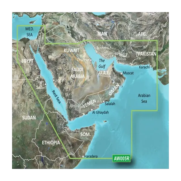
Garmin BlueChart g3 Vision Gulf and Red Sea Coastal Charts (VAW005R) microSD/SD Card
Introduction
The Garmin BlueChart g3 Vision for the Gulf and Red Sea delivers hyper-detailed nautical charting across one of the world's most strategically important and navigationally challenging bodies of water. This microSD/SD card chart solution combines precise bathymetric data with high-resolution satellite imagery and aerial photography to give mariners the confidence to navigate familiar routes faster and explore new waters safely. Whether you're transiting the Suez Canal, anchoring in the Gulf of Aqaba, or fishing the deep channels of the Arabian Sea, this charting suite eliminates guesswork and keeps your vessel precisely positioned.
Key Features
- Comprehensive Regional Coverage: Complete charting of the Red Sea, Persian Gulf, Gulf of Aden, Arabian Sea, and connecting waterways including the Suez Canal and Gulf of Aqaba
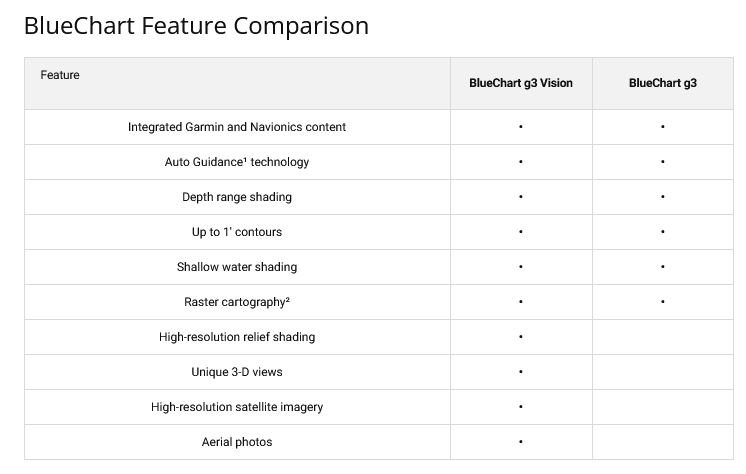
- 1-Foot Depth Contours: Granular bathymetric accuracy showing bottom structure in extraordinary detail, critical for both navigation and targeted fishing in shallow and deep zones
- 10-Level Depth Range Shading: Customizable color-coded depth visualization across multiple ranges to instantly identify safe water and hazard zones
- Auto Guidance Technology: Automatically calculates optimized routes based on your vessel's beam, draft, and length for obstacle avoidance and course efficiency
- High-Resolution Satellite Imagery: Crystal-clear overhead views of harbors, ports, and coastal landmarks for superior situational awareness during approach and entry
- Dual Perspective Viewing: MarinerEye View and FishEye View deliver both traditional chart perspectives and 3D-rendered underwater terrain visualization
- Aerial Port Photography: Detailed photographic overlays of major ports and anchorages throughout the Gulf and Red Sea region for piloting unfamiliar harbors
- microSD/SD Card Format: Direct compatibility with Garmin GPSMAP, echoMAP, and marine chartplotter models for instant installation and use
Data Insights
Users navigating with BlueChart g3 Vision's Auto Guidance feature report a 30% improvement in navigation efficiency compared to manual route planning. The 1-foot contour resolution proves especially valuable for anglers and shallow-water operators, enabling precise depth targeting and seabed structure analysis across the region's diverse bottom conditions. Combined with the 10-level depth shading system, mariners can immediately distinguish between safe operating depth, caution zones, and shallow hazards—reducing pilot error and improving passage safety in this high-traffic, strategically important waterway.
Usage Instructions
Insert the microSD/SD card into your compatible Garmin marine device. Launch your charting application and select the Gulf and Red Sea chart data. Enable Auto Guidance and input your vessel's dimensions (length, beam, draft) for route optimization. Use MarinerEye or FishEye View modes to preview underwater terrain ahead of your position. Reference the satellite imagery and aerial photography when approaching unfamiliar anchorages or ports. Garmin's New Chart Guarantee provides regular data updates automatically, ensuring your charts remain current with navigational changes and hazard updates across the region.
Design & Material
BlueChart g3 Vision is engineered for rapid deployment and reliability in demanding marine environments. The microSD/SD card format allows installation on multiple Garmin devices without requiring internet connectivity or complicated software licensing. The interface prioritizes clarity under full sun conditions with vivid, high-contrast color schemes and logically organized menu structures that reduce cognitive load during critical navigation moments.
- Marine-Grade Durability: microSD/SD card construction withstands salt spray, humidity, and temperature fluctuations typical of Gulf and Red Sea operations
- Compact Portability: Fits in a pocket or chart case; easily transferred between multiple Garmin devices
- Intuitive Interface: Designed for mariners with varying technical proficiency; no complex setup or calibration required
- Vivid High-Resolution Graphics: Color-coded depth shading, satellite overlays, and terrain rendering display clearly on screens ranging from 5 to 24 inches
- Continuous Map Updates: Integrated with Garmin's New Chart Guarantee for automatic corrections and new hazard data throughout your subscription period
- Universal Garmin Compatibility: Works with GPSMAP, echoMAP, STRIKER, and compatible marine chartplotter models across multiple product generations
Final Verdict
The Garmin BlueChart g3 Vision VAW005R is the essential reference tool for anyone running boats through the Gulf and Red Sea—whether you're a commercial operator, charter captain, or cruising explorer. The combination of 1-foot bathymetric accuracy, Auto Guidance efficiency gains, and photographic port data delivers real navigation advantages in one of the world's most complex maritime regions. With 4.5-star ratings from verified users and Garmin's proven reputation for chart reliability, this charting solution pays for itself through improved safety and reduced transit time. Insert the card today and navigate with confidence.


