


Garmin The Gulf Coastal Charts BlueChart g3 Vision | VAW450S | microSD/SD
Garmin The Gulf Coastal Charts BlueChart g3 Vision | VAW450S | microSD/SD
Model Number: 010-C0758-00
In stock
 WhatsApp
 SMS - Text us!
 Email Us!
 Help Desk

Tech Specs
In The Box
Do you have an old GPS unit lying around? The GPS Nation Trade In and Up program is a great way to trade in your old and used GPS for credit towards a new GPS. The choice is entirely yours! We’ve made the process simple and streamlined. Follow these simple steps, and you will be on your way to receiving credit towards your brand new GPS!
1. Get a quote
To get your free quote, provide your GPS type, manufacturer, model, and condition. Within 24 hours, you will receive a quote for the trade-in value of your current product. The GPS trade-in/trade-up form is at the bottom of this page.
2. Ship your product(s) for trade
After accepting our offer, pack your product(s) safely and ship them to us using the pre-paid shipping label provided to you. We will provide a confirmation email when your trade-in arrives at our warehouse. You have 30 days from the date you complete your on-line trade to ship the product to GPS Nation.
3. Make your purchase
Once we receive your product at our warehouse and we validate the stated condition, we will send you a confirmation email. If you elect to receive credit towards a new GPS at gpsnation.com, your store credit will be issued, and you are free to make your purchase.
Manual & Warranty
 Garmin Warranty
Reviews
Ask a Question
Tech Specs
In The Box
Trade-In
Do you have an old GPS unit lying around? The GPS Nation Trade In and Up program is a great way to trade in your old and used GPS for credit towards a new GPS. The choice is entirely yours! We’ve made the process simple and streamlined. Follow these simple steps, and you will be on your way to receiving credit towards your brand new GPS!
1. Get a quote
To get your free quote, provide your GPS type, manufacturer, model, and condition. Within 24 hours, you will receive a quote for the trade-in value of your current product. The GPS trade-in/trade-up form is at the bottom of this page.
2. Ship your product(s) for trade
After accepting our offer, pack your product(s) safely and ship them to us using the pre-paid shipping label provided to you. We will provide a confirmation email when your trade-in arrives at our warehouse. You have 30 days from the date you complete your on-line trade to ship the product to GPS Nation.
3. Make your purchase
Once we receive your product at our warehouse and we validate the stated condition, we will send you a confirmation email. If you elect to receive credit towards a new GPS at gpsnation.com, your store credit will be issued, and you are free to make your purchase.
Manual & Warranty
Overview
Garmin BlueChart g3 Vision VAW450S Gulf Coastal Charts | microSD/SD Card for Precision Marine Navigation
Introduction
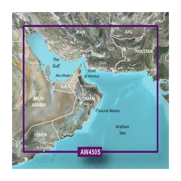
The Garmin BlueChart g3 Vision VAW450S delivers detailed nautical charting specifically mapped for The Gulf region, including waters around Kuwait, Saudi Arabia, Qatar, and the Iranian coast. This microSD/SD card transforms compatible Garmin marine GPS devices into advanced navigation platforms, combining official hydrographic data with private charting sources to provide the depth accuracy and route calculation capabilities serious boaters and commercial operators require for safe passage in complex coastal waters.
Key Features
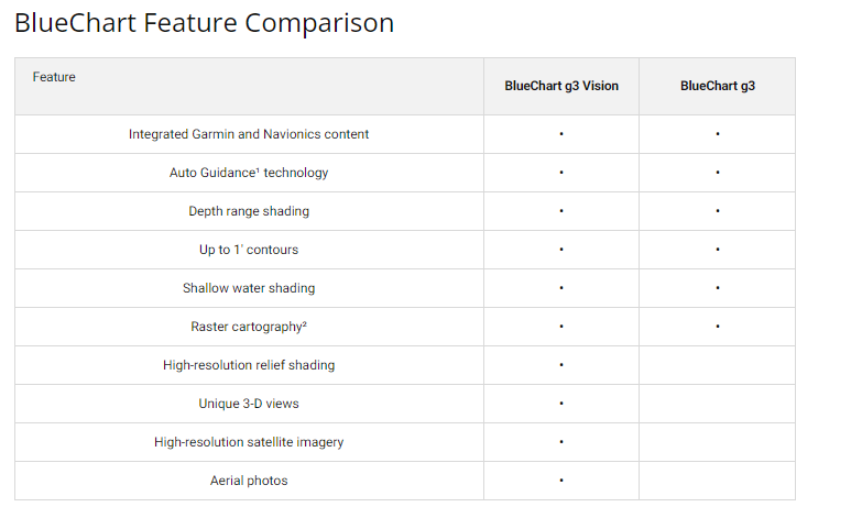
- Auto Guidance Technology that calculates safe passage routes based on your vessel's beam, draft, and length specifications
- 1-foot contour intervals for precise bottom structure mapping critical to commercial and recreational fishing operations
- Up to 10 customizable depth range shading options, enabling real-time visual distinction between safe and shallow waters
- Depth-based tidal information compiled from official nautical sources for informed departure and arrival planning
- 80% more data coverage compared to previous BlueChart generations, expanding navigational reference points across the mapped region
- MarinerEye and FishEye 3D perspective views that display above-water landmarks and subsurface terrain simultaneously
Data Insights
This chart card incorporates comprehensive hydrographic data derived from official marine surveying agencies and private maritime sources. The expanded dataset provides significantly enhanced navigational detail across The Gulf, with particular emphasis on critical shipping lanes near Abu Dhabi, Muscat, and the Strait of Hormuz. The inclusion of high-resolution satellite imagery allows users to correlate landmark positions with traditional depth contours, reducing reliance on single-source navigation during passage through congested or shallow-draft corridors.
Usage Instructions
Insert the microSD/SD card into a compatible Garmin marine chartplotter or GPS device. Once initialized, access the BlueChart g3 Vision data through your device's chart selection menu. Configure Auto Guidance by entering your vessel's dimensions—beam, length, and draft—then activate suggested route calculation for your intended destination. Use the customizable depth shading to highlight hazardous shallow areas specific to your draft requirements, and reference the 3D view options when familiarizing yourself with unfamiliar passages or anchorages.
Design & Material
The BlueChart g3 Vision arrives as a pre-programmed microSD/SD card requiring no manual data input or activation codes. The compact card format eliminates bulky external storage and integrates seamlessly into standard Garmin device slots. All chart data, imagery, and 3D rendering information load directly from the card, ensuring consistent performance regardless of your device's internal memory capacity.
- Pre-loaded with complete Gulf coastal mapping, tidal tables, and satellite reference imagery
- Durable card construction rated for marine-grade temperature and humidity ranges
- Compatible with Garmin devices supporting microSD/SD card expansion (model 010-C0758-00 specification)
- High-resolution satellite imagery layered beneath chart data for dual-reference navigation confirmation
- Intuitive device interface displays chart features without requiring external software installation
- Shallow water shading algorithm customizable to vessel-specific draft measurements for personalized hazard visualization
Final Verdict
The Garmin BlueChart g3 Vision VAW450S is essential for any mariner navigating The Gulf's complex waterways, whether you operate commercially or recreationally. The combination of precision 1-foot contours, vessel-specific Auto Guidance, and significantly expanded data coverage eliminates guesswork from route planning while improving situational awareness in confined waters. Order this chart card today to gain the navigational confidence and detailed coastal intelligence your device was designed to deliver.


