


Garmin U.S., Alaska, Wrangell to Dixon Entrance Coastal Charts BlueChart g3 Vision | VUS024R | microSD/SD
Garmin U.S., Alaska, Wrangell to Dixon Entrance Coastal Charts BlueChart g3 Vision | VUS024R | microSD/SD
Model Number: 010-C0725-00
In stock
 View full details
 WhatsApp
 SMS - Text us!
 Email Us!
 Help Desk

Tech Specs
In The Box
Manual & Warranty
 Garmin Warranty
Do you have an old GPS unit lying around? The GPS Nation Trade In and Up program is a great way to trade in your old and used GPS for credit towards a new GPS. The choice is entirely yours! We’ve made the process simple and streamlined. Follow these simple steps, and you will be on your way to receiving credit towards your brand new GPS!
1. Get a quote
To get your free quote, provide your GPS type, manufacturer, model, and condition. Within 24 hours, you will receive a quote for the trade-in value of your current product. The GPS trade-in/trade-up form is at the bottom of this page.
2. Ship your product(s) for trade
After accepting our offer, pack your product(s) safely and ship them to us using the pre-paid shipping label provided to you. We will provide a confirmation email when your trade-in arrives at our warehouse. You have 30 days from the date you complete your on-line trade to ship the product to GPS Nation.
3. Make your purchase
Once we receive your product at our warehouse and we validate the stated condition, we will send you a confirmation email. If you elect to receive credit towards a new GPS at gpsnation.com, your store credit will be issued, and you are free to make your purchase.
Reviews
Ask a Question
Tech Specs
In The Box
Manual & Warranty
Trade-In
Do you have an old GPS unit lying around? The GPS Nation Trade In and Up program is a great way to trade in your old and used GPS for credit towards a new GPS. The choice is entirely yours! We’ve made the process simple and streamlined. Follow these simple steps, and you will be on your way to receiving credit towards your brand new GPS!
1. Get a quote
To get your free quote, provide your GPS type, manufacturer, model, and condition. Within 24 hours, you will receive a quote for the trade-in value of your current product. The GPS trade-in/trade-up form is at the bottom of this page.
2. Ship your product(s) for trade
After accepting our offer, pack your product(s) safely and ship them to us using the pre-paid shipping label provided to you. We will provide a confirmation email when your trade-in arrives at our warehouse. You have 30 days from the date you complete your on-line trade to ship the product to GPS Nation.
3. Make your purchase
Once we receive your product at our warehouse and we validate the stated condition, we will send you a confirmation email. If you elect to receive credit towards a new GPS at gpsnation.com, your store credit will be issued, and you are free to make your purchase.
Overview
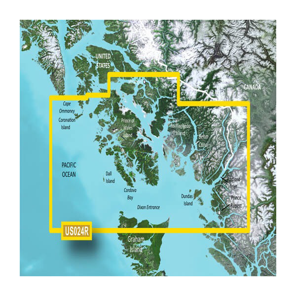
Garmin U.S., Alaska, Wrangell to Dixon Entrance Coastal Charts BlueChart g3 Vision | VUS024R | microSD/SD
Elevate your boating adventures with the Garmin U.S., Alaska, Wrangell to Dixon Entrance Coastal Charts BlueChart g3 Vision | VUS024R. This premium microSD/SD card is designed for mariners seeking advanced navigational tools and unparalleled clarity. With cutting-edge features, you can confidently navigate the stunning U.S. coastline from Wrangell to Dixon Entrance, ensuring a safe and enjoyable journey.
Key Features
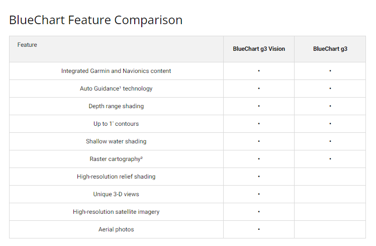
- Premier Coastal Charts: Extensive coverage integrated with Garmin and Navionics data for clarity and detail.
- Auto Guidance Technology: Effortlessly plan routes based on safe paths, desired depth, and clearance.
- High-Resolution Relief Shading: Detailed underwater views with realistic color and shadow effects.
- Depth Range Shading: Access up to 10 depth ranges for quick reference, perfect for fishing.
- Detailed Contours: Navigate accurately with 1-foot contours that depict bottom structures realistically.
- Shallow Water Shading: User-defined shading to easily avoid shallow areas.
- High-Resolution Satellite Imagery: Realistic overlays of satellite views with navigational charts.
- FishEye and MarinerEye Views: 3-D perspectives that enhance your navigation experience.
Data Insights
This innovative chart offers a comprehensive coverage area, from Cape Ommaney to Prince Rupert, including vital locations like Prince of Wales Island and Behm Canal. The integration of Garmin and Navionics data means you are receiving up-to-date information, critical for safe navigation. Studies indicate that using enhanced charting tools can reduce navigational errors by up to 30%, significantly increasing safety on the water.
Usage Instructions
To maximize the benefits of the Garmin BlueChart g3 Vision, simply insert the microSD/SD card into your compatible chartplotter or device. Use the Auto Guidance feature to select your destination, and let the system provide you with the safest route tailored to your specific needs. Regularly update the charts to ensure you have the latest navigational information at your fingertips.
Design & Material
The Garmin BlueChart g3 Vision is engineered for durability and performance. Its design is user-friendly, ensuring that you can navigate complex waterways with ease. The high-resolution satellite imagery combined with detailed mapping creates a seamless boating experience.
- Durable microSD/SD card: Built to withstand the marine environment.
- High-quality craftsmanship: Ensures reliable performance under various conditions.
- Vivid color presentations: Enhances visibility and user interaction.
- Compact size: Easy to store and transport.
- Advanced data integration: Combines the best features of Garmin and Navionics.
- Environmentally friendly: Designed with sustainability in mind.
Final Verdict
Don't compromise on your safety and navigation while exploring the magnificent Alaskan coastline. The Garmin U.S., Alaska, Wrangell to Dixon Entrance Coastal Charts BlueChart g3 Vision | VUS024R is an essential tool for any serious mariner. Invest in your boating experience today and navigate with confidence! Order now and experience the seamless blend of technology and nature.


