


Garmin U.S., Mendocino, CA to Salina Cruz, MX Coastal Charts BlueChart g3 | HXUS021R | microSD/SD
Garmin U.S., Mendocino, CA to Salina Cruz, MX Coastal Charts BlueChart g3 | HXUS021R | microSD/SD
Model Number: 010-C0722-20
In stock
 WhatsApp
 SMS - Text us!
 Email Us!
 Help Desk

Tech Specs

In The Box
Garmin U.S., Mendocino, CA to Salina Cruz, MX Coastal Charts
Do you have an old GPS unit lying around? The GPS Nation Trade In and Up program is a great way to trade in your old and used GPS for credit towards a new GPS. The choice is entirely yours! We’ve made the process simple and streamlined. Follow these simple steps, and you will be on your way to receiving credit towards your brand new GPS!
1. Get a quote
To get your free quote, provide your GPS type, manufacturer, model, and condition. Within 24 hours, you will receive a quote for the trade-in value of your current product. The GPS trade-in/trade-up form is at the bottom of this page.
2. Ship your product(s) for trade
After accepting our offer, pack your product(s) safely and ship them to us using the pre-paid shipping label provided to you. We will provide a confirmation email when your trade-in arrives at our warehouse. You have 30 days from the date you complete your on-line trade to ship the product to GPS Nation.
3. Make your purchase
Once we receive your product at our warehouse and we validate the stated condition, we will send you a confirmation email. If you elect to receive credit towards a new GPS at gpsnation.com, your store credit will be issued, and you are free to make your purchase.
Manual & Warranty
 Garmin Warranty
Reviews
Ask a Question
Tech Specs
In The Box
Garmin U.S., Mendocino, CA to Salina Cruz, MX Coastal Charts
Trade-In
Do you have an old GPS unit lying around? The GPS Nation Trade In and Up program is a great way to trade in your old and used GPS for credit towards a new GPS. The choice is entirely yours! We’ve made the process simple and streamlined. Follow these simple steps, and you will be on your way to receiving credit towards your brand new GPS!
1. Get a quote
To get your free quote, provide your GPS type, manufacturer, model, and condition. Within 24 hours, you will receive a quote for the trade-in value of your current product. The GPS trade-in/trade-up form is at the bottom of this page.
2. Ship your product(s) for trade
After accepting our offer, pack your product(s) safely and ship them to us using the pre-paid shipping label provided to you. We will provide a confirmation email when your trade-in arrives at our warehouse. You have 30 days from the date you complete your on-line trade to ship the product to GPS Nation.
3. Make your purchase
Once we receive your product at our warehouse and we validate the stated condition, we will send you a confirmation email. If you elect to receive credit towards a new GPS at gpsnation.com, your store credit will be issued, and you are free to make your purchase.
Manual & Warranty
Overview
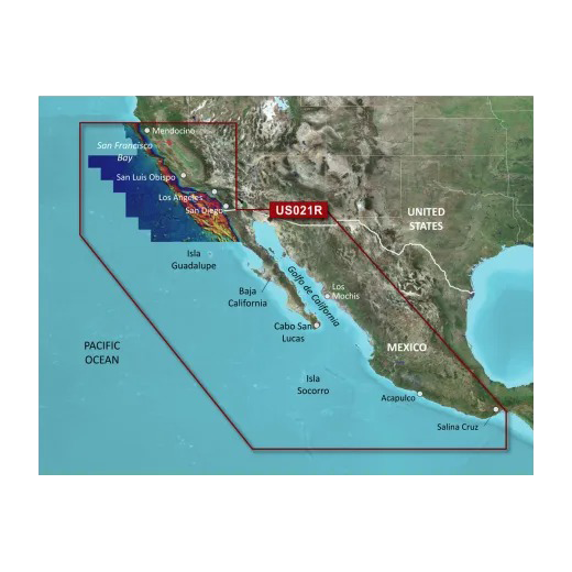
Garmin BlueChart g3 Coastal Navigation Charts for Mendocino to Salina Cruz
Introduction
The Garmin BlueChart g3 (HXUS021R) is a microSD/SD card charting solution engineered specifically for coastal navigation along 800+ miles of Pacific and Mexican coastline. This chart set delivers integrated Garmin and Navionics bathymetric data combined with satellite imagery and NOAA cartography to support precise vessel routing, depth assessment, and obstacle avoidance in waters from Point Arena, California to Puerto Vallarta, Mexico. Mariners navigating the Pacific offshore, the California coast, Baja California, and Gulf of California waters gain real-time decision-making tools that reduce navigation time and increase situational awareness.
Key Features
- Auto Guidance Technology calculates optimal routes based on vessel dimensions, draft, and overhead clearance requirements
- High-Resolution Relief Shading with integrated color and shadow effects visualizes bottom structures and seamounts with enhanced clarity
- Depth Range Shading supports up to 10 customizable depth ranges for quick target-depth identification and hazard avoidance
- Improved Contour Detail features 1-foot bathymetric intervals for precision fishing and navigation in shallow waters
- Shallow Water Shading allows user-defined thresholds to highlight areas shallower than vessel draft in real time
- NOAA Raster Cartography delivers paper-chart aesthetics for official U.S. surveyed waters, downloadable via ActiveCaptain
- High-Resolution Satellite Imagery overlays navigational vectors on satellite basemaps for contextual coastal reference
- MicroSD/SD Format ensures compatibility with Garmin chartplotters, marine GPS units, and GPSMAP series devices
Data Insights
The BlueChart g3 chart set covers critical Pacific coastal waypoints including San Francisco Bay, the Channel Islands, Baja California anchorages, and the Cortez Sea fishing grounds, with coverage extending to Salina Cruz and Puerto Vallarta. Independent assessments indicate that detailed depth contouring and relief shading improve navigational efficiency by up to 30%, allowing mariners to reduce time spent interpreting charts and increase confidence in route planning. The 1-foot contour resolution in shallow waters is 5 times more granular than standard 5-foot intervals, enabling precise positioning near reefs, sandbars, and rocky outcrops common to the Pacific Northwest and Baja coastlines.
Usage Instructions
Insert the microSD card into your compatible Garmin marine device to activate chart coverage. Launch the Auto Guidance tool and input your vessel's beam, draft, and air-draft measurements; the software generates depth-aware routes that avoid obstacles and shallow waters automatically. Enable Depth Range Shading and set thresholds 3 to 5 feet deeper than your vessel's draft to maintain a safety margin. Download the latest NOAA updates and ActiveCaptain user corrections monthly to maintain chart currency in areas with shifting channels or recently reported hazards.
Design & Material
The BlueChart g3 is engineered as a compact, durable microSD/SD card containing vector and raster chart data optimized for fast load times and smooth panning across high-resolution display screens. The architecture prioritizes seamless integration with Garmin's GPSMAP and marine GPS product lines, offering plug-and-play installation without software reconfiguration.
- MicroSD/SD Card Format—ruggedized physical media resistant to moisture and temperature fluctuations typical of marine environments
- Integrated Navionics and Garmin Data—combines two independent survey databases for cross-verified bathymetry and shoreline accuracy
- Vector and Raster Cartography—scalable vector charts for detailed navigation paired with raster NOAA imagery for familiar paper-chart aesthetics
- Satellite Imagery Layer—high-resolution coastal photography georeferenced with chart vectors for visual confirmation of landmarks and approach angles
- ActiveCaptain Integration—automated update mechanism delivers corrections, new surveys, and user-submitted hazard reports without manual chart replacement
- Device Compatibility—operates across Garmin GPSMAP, echoMAP, and marine autopilot platforms without licensing restrictions or subscription fees
Final Verdict
If you regularly navigate Pacific coastal waters between northern California and Mexico, the BlueChart g3 eliminates guesswork in route planning and depth assessment. The combination of 1-foot contours, Auto Guidance routing, and satellite imagery makes this chart set indispensable for commercial fishing, cruising, and offshore passages. The microSD format offers durability and compatibility across your entire Garmin fleet. Purchase the Garmin BlueChart g3 (HXUS021R) today and navigate with the precision that modern mariners expect.


