


Garmin U.S., Mendocino, CA to Salina Cruz, MX Coastal Charts BlueChart g3 Vision | VUS021R | microSD/SD
Garmin U.S., Mendocino, CA to Salina Cruz, MX Coastal Charts BlueChart g3 Vision | VUS021R | microSD/SD
Model Number: 010-C0722-00
In stock
 WhatsApp
 SMS - Text us!
 Email Us!
 Help Desk


Tech Specs
In The Box
Do you have an old GPS unit lying around? The GPS Nation Trade In and Up program is a great way to trade in your old and used GPS for credit towards a new GPS. The choice is entirely yours! We’ve made the process simple and streamlined. Follow these simple steps, and you will be on your way to receiving credit towards your brand new GPS!
1. Get a quote
To get your free quote, provide your GPS type, manufacturer, model, and condition. Within 24 hours, you will receive a quote for the trade-in value of your current product. The GPS trade-in/trade-up form is at the bottom of this page.
2. Ship your product(s) for trade
After accepting our offer, pack your product(s) safely and ship them to us using the pre-paid shipping label provided to you. We will provide a confirmation email when your trade-in arrives at our warehouse. You have 30 days from the date you complete your on-line trade to ship the product to GPS Nation.
3. Make your purchase
Once we receive your product at our warehouse and we validate the stated condition, we will send you a confirmation email. If you elect to receive credit towards a new GPS at gpsnation.com, your store credit will be issued, and you are free to make your purchase.
Manual & Warranty
 Garmin Warranty
Reviews
Ask a Question
Tech Specs
In The Box
Trade-In
Do you have an old GPS unit lying around? The GPS Nation Trade In and Up program is a great way to trade in your old and used GPS for credit towards a new GPS. The choice is entirely yours! We’ve made the process simple and streamlined. Follow these simple steps, and you will be on your way to receiving credit towards your brand new GPS!
1. Get a quote
To get your free quote, provide your GPS type, manufacturer, model, and condition. Within 24 hours, you will receive a quote for the trade-in value of your current product. The GPS trade-in/trade-up form is at the bottom of this page.
2. Ship your product(s) for trade
After accepting our offer, pack your product(s) safely and ship them to us using the pre-paid shipping label provided to you. We will provide a confirmation email when your trade-in arrives at our warehouse. You have 30 days from the date you complete your on-line trade to ship the product to GPS Nation.
3. Make your purchase
Once we receive your product at our warehouse and we validate the stated condition, we will send you a confirmation email. If you elect to receive credit towards a new GPS at gpsnation.com, your store credit will be issued, and you are free to make your purchase.
Manual & Warranty
Overview
Garmin BlueChart g3 Vision Coastal Charts VUS021R | Mendocino CA to Salina Cruz Mexico
Introduction
The Garmin BlueChart g3 Vision (model VUS021R) delivers high-resolution coastal charting for Pacific waters between Mendocino, California and Salina Cruz, Mexico. This microSD/SD card integrates Garmin and Navionics data into a single charting solution designed for serious fishing and cruising along the U.S. West Coast and into Mexican waters. The combination of advanced depth shading, detailed contours, and automated route calculation gives you the navigational clarity needed to fish effectively and cruise safely through unfamiliar coastal terrain.
Key Features
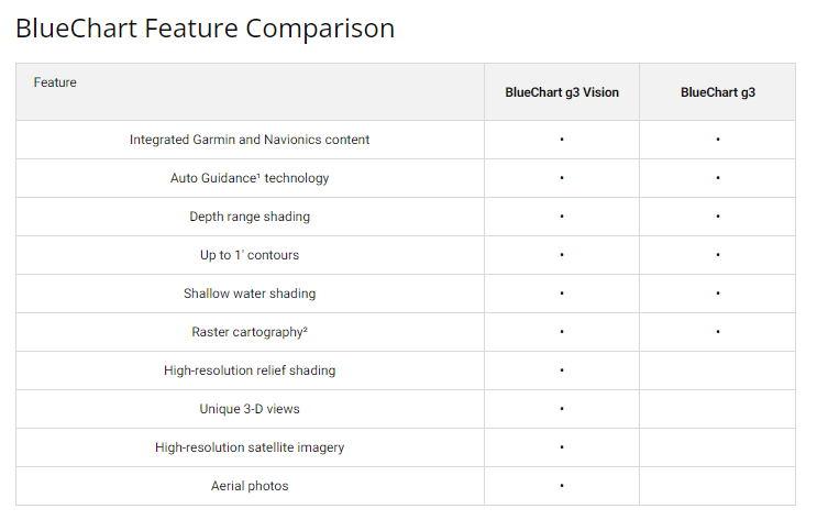
- Integrated Garmin and Navionics Data: Combines two trusted data sources for enhanced accuracy across the entire coverage region
- Auto Guidance Technology: Calculates optimal routes based on user-defined depth requirements and overhead clearance specifications
- High-Resolution Depth Range Shading: Displays up to 10 distinct depth ranges with color differentiation for quick visual reference while navigating
- 1-Foot Contour Lines: Delivers precise bathymetric detail for improved fishing location identification and safe passage through shallow areas
- High-Resolution Relief Shading: Creates layered color and shadow effects that clearly visualize underwater structure and topology
- Customizable Shallow Water Shading: Allows users to define depth thresholds for identifying and avoiding hazardous shallow zones
- MicroSD/SD Card Format: Compact storage media compatible with Garmin navigation systems for plug-and-play installation
Data Insights
The BlueChart g3 Vision provides comprehensive coverage spanning from Point Arena, California to Puerto Vallarta, Mexico—a distance encompassing major fishing grounds, island systems including Isla Guadalupe, Baja California, and the Sea of Cortez access routes. The integration of high-resolution depth data at 1-foot contour intervals gives anglers and cruisers significantly better precision for identifying structure, drop-offs, and navigable channels compared to standard charting solutions. This level of detail proves essential for consistency when targeting specific depths in productive fishing zones along the Pacific coast.
Usage Instructions
Install the microSD/SD card directly into your compatible Garmin chartplotter or GPS unit. Once inserted, the chart data loads automatically. Use the Auto Guidance feature by entering your vessel's draft, air draft, and preferred routing preferences—the system then calculates safe waypoints and routes accordingly. For maximum accuracy, check for chart updates periodically through your Garmin device to access the latest navigational corrections and data refinements from Garmin and Navionics.
Design & Material
The BlueChart g3 Vision is engineered for durability in saltwater environments while maintaining a compact, portable format. The card-based design fits standard microSD/SD slots found in modern Garmin marine electronics, eliminating bulky external hardware. Crystal-clear imagery and intuitive chart organization ensure quick interpretation whether you're monitoring depth changes during approach or planning multi-day passages.
- Integrated Garmin and Navionics Data: Two authoritative charting databases merged for superior accuracy and coverage completeness
- Compact MicroSD/SD Format: Easy storage, transport, and installation in any compatible Garmin device without extra mounting hardware
- High-Resolution Satellite Imagery: Realistic visual representation of coastal features, ports, and landmarks for easier navigation and waypoint planning
- Durable Digital Format: No physical wear, no printed chart deterioration—data remains accessible for years without degradation
- User-Friendly Interface: Intuitive color coding, depth shading, and symbol conventions work across all compatible Garmin navigation systems
- Regular Update Compatibility: Designed to receive ongoing chart corrections and data enhancements through Garmin update services
Final Verdict
If you fish or cruise the Pacific coast from Northern California through Mexican waters, the Garmin BlueChart g3 Vision eliminates guesswork from your navigation. The combination of integrated data, precise depth contouring, and Auto Guidance functionality transforms how you read coastal structure and plan safe passages. This is not optional equipment for serious mariners in this region—it's a fundamental tool that pays for itself through improved catch location, fewer navigational errors, and confidence in unfamiliar waters. Order the VUS021R today and gain the detailed charting your Garmin device deserves.


