


Garmin U.S., South Florida and North Bahamas Coastal Charts BlueChart g3 Vision | VUS010R | microSD/SD
Garmin U.S., South Florida and North Bahamas Coastal Charts BlueChart g3 Vision | VUS010R | microSD/SD
Model Number: 010-C0711-00
In stock
 WhatsApp
 SMS - Text us!
 Email Us!
 Help Desk

Tech Specs
In The Box
Do you have an old GPS unit lying around? The GPS Nation Trade In and Up program is a great way to trade in your old and used GPS for credit towards a new GPS. The choice is entirely yours! We’ve made the process simple and streamlined. Follow these simple steps, and you will be on your way to receiving credit towards your brand new GPS!
1. Get a quote
To get your free quote, provide your GPS type, manufacturer, model, and condition. Within 24 hours, you will receive a quote for the trade-in value of your current product. The GPS trade-in/trade-up form is at the bottom of this page.
2. Ship your product(s) for trade
After accepting our offer, pack your product(s) safely and ship them to us using the pre-paid shipping label provided to you. We will provide a confirmation email when your trade-in arrives at our warehouse. You have 30 days from the date you complete your on-line trade to ship the product to GPS Nation.
3. Make your purchase
Once we receive your product at our warehouse and we validate the stated condition, we will send you a confirmation email. If you elect to receive credit towards a new GPS at gpsnation.com, your store credit will be issued, and you are free to make your purchase.
Manual & Warranty
 Garmin Warranty
Reviews
Ask a Question
Tech Specs
In The Box
Trade-In
Do you have an old GPS unit lying around? The GPS Nation Trade In and Up program is a great way to trade in your old and used GPS for credit towards a new GPS. The choice is entirely yours! We’ve made the process simple and streamlined. Follow these simple steps, and you will be on your way to receiving credit towards your brand new GPS!
1. Get a quote
To get your free quote, provide your GPS type, manufacturer, model, and condition. Within 24 hours, you will receive a quote for the trade-in value of your current product. The GPS trade-in/trade-up form is at the bottom of this page.
2. Ship your product(s) for trade
After accepting our offer, pack your product(s) safely and ship them to us using the pre-paid shipping label provided to you. We will provide a confirmation email when your trade-in arrives at our warehouse. You have 30 days from the date you complete your on-line trade to ship the product to GPS Nation.
3. Make your purchase
Once we receive your product at our warehouse and we validate the stated condition, we will send you a confirmation email. If you elect to receive credit towards a new GPS at gpsnation.com, your store credit will be issued, and you are free to make your purchase.
Manual & Warranty
Overview
Garmin BlueChart g3 Vision Coastal Charts for South Florida and North Bahamas
Introduction
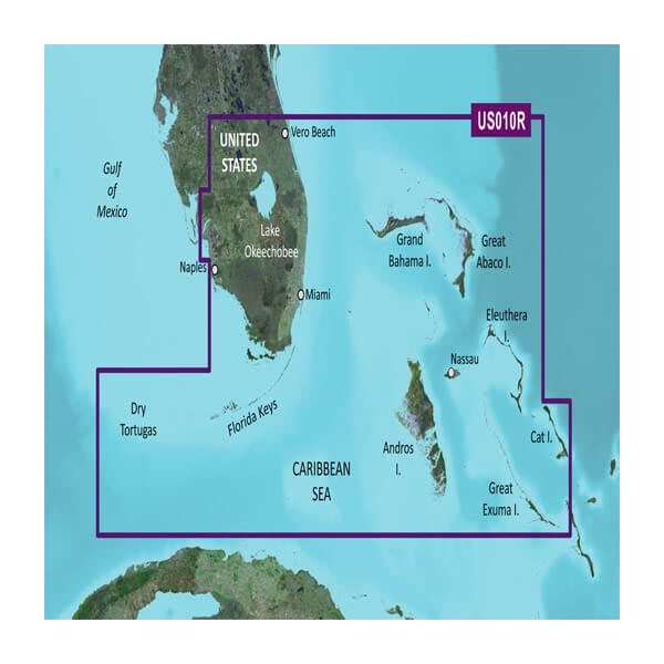
The Garmin BlueChart g3 Vision VUS010R microSD/SD card delivers precision navigation for South Florida and North Bahamas coastal waters. This chart solution combines high-definition satellite imagery with integrated Garmin and Navionics data to give you a 20% increase in mapping detail compared to earlier models. Whether you're navigating shallow inlets, offshore reefs, or fishing hotspots in the Caribbean and Gulf of Mexico regions, this charting system provides the accurate, real-time data you need for confident on-water decisions.
Key Features
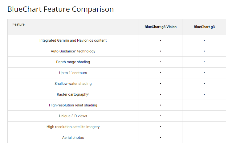
- Auto Guidance Technology calculates safe routes automatically based on your vessel's depth requirements and overhead clearance settings
- Depth range shading displays up to 10 distinct depth zones for target-specific fishing and navigation planning
- Precise 1-foot contours throughout swamps, canals, ports, and shallow-water areas for exact position reference
- High-resolution relief shading reveals detailed underwater bottom structure and terrain variations
- Shallow water shading with user-defined parameters highlights hazardous areas to avoid navigation risks
- Integrated Garmin and Navionics data provides comprehensive coverage across coastal Florida, Bahamas, and surrounding waters
Data Insights
BlueChart g3 Vision performs with high-definition satellite imagery technology that delivers a 20% improvement in charting detail over previous generations. The system's dual-source data integration ensures consistent accuracy across the South Florida coastline, Florida Keys, Dry Tortugas, and North Bahamas island chains. Advanced contour mapping and depth visualization help anglers identify structure and help boaters navigate complex waterways with reduced uncertainty.
Usage Instructions
Insert the microSD/SD card into your compatible Garmin chartplotter or marine GPS unit to activate full chart coverage immediately. Enable Auto Guidance to have the system calculate safe passage routes that respect your vessel's beam and draft specifications. Review depth range shading to identify fishing zones, and customize shallow water alerts based on your specific navigation requirements. Periodically update charts through your Garmin device to access the latest surveyed data and features.
Design & Material
The BlueChart g3 Vision card is engineered as a compact microSD/SD format that installs directly into standard Garmin marine electronics without requiring external connections or power. Its durable construction withstands the salt spray, humidity, and temperature fluctuations inherent to marine environments while maintaining reliable data integrity across extended boating seasons.
- MicroSD/SD card format fits all compatible Garmin chartplotters and handheld GPS devices
- Durable construction rated for marine environments and salt-water exposure
- Dual-source Garmin and Navionics data integration for comprehensive accuracy
- High-resolution satellite imagery backing for precise coastal and inland charting
- User-customizable depth ranges, contours, and shallow water alert thresholds
- Seamless installation with no additional software or configuration required
Final Verdict
The Garmin BlueChart g3 Vision VUS010R is the essential navigation tool for anyone boating or fishing in South Florida and Bahamas waters. Its combination of precise 1-foot contours, Auto Guidance routing, and detailed underwater relief mapping removes guesswork from navigation and fishing decisions. This chart solution transforms your Garmin device into a professional-grade navigation platform comparable to systems costing significantly more. Install this card today and gain immediate access to the most detailed coastal mapping available for your region.


